Perrier geodata
Perrier (Auvergne-Rhône-Alpes) is a populated place; located in France in Europe/Paris (GMT+2) time zone. With population of 823 people, there are 10361 cities with bigger population in this country. Compared to other cities in France, 73.5% of cities are located further ↑North; 60.5% of cities are located further ←West and 89.9% of cities have lower elevation than Perrier. Note1
Administrative division(s):
- Level 1: Auvergne-Rhône-Alpes
- Level 2: Département du Puy-de-Dôme
- Level 3: Issoire
- Level 4: Perrier


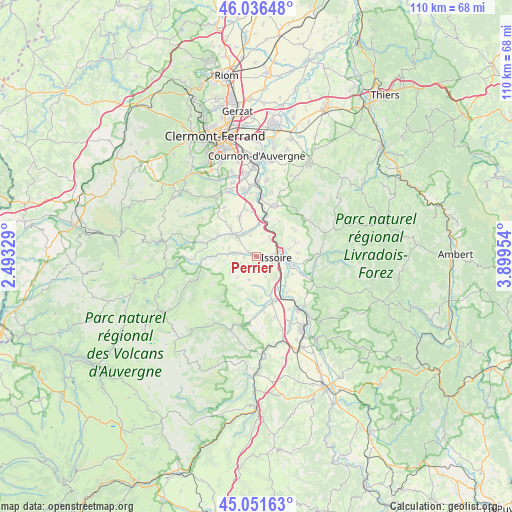
Perrier GPS coordinates[2]
45° 32' 46.356" North, 3° 11' 47.112" East
| Map corner | latitude | longitude |
|---|---|---|
| Upper-left | 46.03648°, | 2.49329° |
| Center: | 45.54621°, | 3.19642° |
| Lower-right: | 45.05163°, | 3.89954° |
| Map W x H: | 109.5×109.5 km | = 68×68mi |
| max Lat: | 51.07786° ⇑73.5% North |
| Perrier: | 45.54621° |
| min Lat: | ⇓26.5% South 41.3874° |
| min Long | Perrier | max Long |
| -5.08615° | 3.19642° | 9.52242° |
| W 60.5%⇐ | ⇒39.5% E |
Elevation
Elevation of Perrier is 424 m = 1391 ft, and this is 230.3 m = 756 ft above average elevation for this country.
| Max E: |
2333 m = 7654 ft | 10.1% |
| Perrier | 424 m 1391 ft | |
| Avg. | 193.7 m = 635 ft | |
Min E: |
-1 m = -3 ft | 89.9% |
See also: France elevation on elevation.city.
Geographical zone
Perrier is located in North temperate zone (between Tropic of Cancer and the Arctic Circle). Distance of this North polar circle is 2336.9 km =1452.1 mi to North.| Distance of | km | miles | from Perrier |
|---|---|---|---|
| North Pole | 4942.8 | 3071.3 | to North |
| Arctic Circle | 2336.9 | 1452.1 | to North |
| Tropic Cancer | 2458.3 | 1527.5 | to South |
| Equator | 5064.3 | 3146.8 | to South |


Nearby cities:
15 places around Perrier: (largest is in red/bold)
• Authezat
9.5 km =5.9 mi,  354°
354°
• Champeix
7.1 km =4.4 mi,  311°
311°
• Coudes
7.7 km =4.8 mi,  6°
6°
• Issoire
4.1 km =2.5 mi,  93°
93°
• Le Breuil-sur-Couze
10.1 km =6.3 mi,  148°
148°
• Le Broc
6.3 km =3.9 mi,  143°
143°
• Montaigut-le-Blanc
9.4 km =5.8 mi,  298°
298°
• Neschers
5.5 km =3.4 mi,  332°
332°
• Orbeil
6.5 km =4 mi,  74°
74°
• Parent
9 km =5.6 mi,  16°
16°
• Parentignat
7.5 km =4.7 mi,  100°
100°
• Plauzat
9.2 km =5.7 mi,  336°
336°
• Saint-Babel
9.8 km =6.1 mi,  55°
55°
• Saint-Germain-Lembron
10.4 km =6.5 mi,  161°
161°
• Yronde
8.8 km =5.5 mi,  31°
31°
Sources, notices
• [Note1] Compared only with cities in France existing in our database
• [Src1] Map data: © OpenStreetMap contributors (CC-BY-SA)
• [Src2] Other city data from geonames.org with taken over terms of usage.
• [Src3] Geographical zone / Annual Mean Temperature by Robert A. Rohde @ Wikipedia
