Laval-Pradel geodata
Laval-Pradel (Occitanie) is a populated place; located in France in Europe/Paris (GMT+2) time zone. With population of 1,075 people, there are 8295 cities with bigger population in this country. Compared to other cities in France, 85.4% of cities are located further ↑North; 68.5% of cities are located further ←West and 74.8% of cities have lower elevation than Laval-Pradel. Note1
Administrative division(s):
- Level 1: Occitanie
- Level 2: Gard
- Level 3: Arrondissement d’Alès
- Level 4: Laval-Pradel


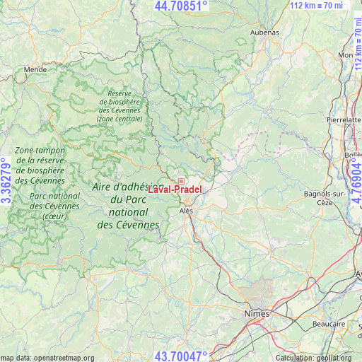
Laval-Pradel GPS coordinates[2]
44° 12' 23.94" North, 4° 3' 57.276" East
| Map corner | latitude | longitude |
|---|---|---|
| Upper-left | 44.70851°, | 3.36279° |
| Center: | 44.20665°, | 4.06591° |
| Lower-right: | 43.70047°, | 4.76904° |
| Map W x H: | 112.1×112.1 km | = 69.7×69.7mi |
| max Lat: | 51.07786° ⇑85.4% North |
| Laval-Pradel: | 44.20665° |
| min Lat: | ⇓14.6% South 41.3874° |
| min Long | Laval-Pradel | max Long |
| -5.08615° | 4.06591° | 9.52242° |
| W 68.5%⇐ | ⇒31.5% E |
Elevation
Elevation of Laval-Pradel is 247 m = 810 ft, and this is 53.3 m = 175 ft above average elevation for this country.
| Max E: |
2333 m = 7654 ft | 25.2% |
| Laval-Pradel | 247 m 810 ft | |
| Avg. | 193.7 m = 635 ft | |
Min E: |
-1 m = -3 ft | 74.8% |
See also: France elevation on elevation.city.
Geographical zone
Laval-Pradel is located in North temperate zone (between Tropic of Cancer and the Arctic Circle). Distance of this Northern Tropic circle is 2309.4 km =1435 mi to South.| Distance of | km | miles | from Laval-Pradel |
|---|---|---|---|
| North Pole | 5091.7 | 3163.8 | to North |
| Arctic Circle | 2485.9 | 1544.7 | to North |
| Tropic Cancer | 2309.4 | 1435 | to South |
| Equator | 4915.3 | 3054.2 | to South |


Nearby cities:
15 places around Laval-Pradel: (largest is in red/bold)
• Alès
9.2 km =5.7 mi,  172°
172°
• Branoux-les-Taillades
5.7 km =3.5 mi,  284°
284°
• Cendras
6.3 km =3.9 mi,  179°
179°
• Le Martinet
5.2 km =3.2 mi,  20°
20°
• Les Mages
8.6 km =5.3 mi,  73°
73°
• Les Salles-du-Gardon
2.3 km =1.4 mi,  273°
273°
• Molières-sur-Cèze
9.4 km =5.8 mi,  51°
51°
• Robiac-Rochessadoule
8.6 km =5.3 mi,  38°
38°
• Rousson
6.8 km =4.2 mi,  104°
104°
• Saint-Florent-sur-Auzonnet
5.3 km =3.3 mi, 44°
• Saint-Jean-de-Valériscle
7 km =4.3 mi, 67°
• Saint-Julien-les-Rosiers
4.9 km =3 mi,  136°
136°
• Saint-Martin-de-Valgalgues
5 km =3.1 mi,  163°
163°
• Saint-Privat-des-Vieux
8.6 km =5.3 mi, 143°
• Salindres
8.5 km =5.3 mi,  117°
117°
Sources, notices
• [Note1] Compared only with cities in France existing in our database
• [Src1] Map data: © OpenStreetMap contributors (CC-BY-SA)
• [Src2] Other city data from geonames.org with taken over terms of usage.
• [Src3] Geographical zone / Annual Mean Temperature by Robert A. Rohde @ Wikipedia
