Alès geodata
Alès (Occitanie) is a seat of a third-order administrative division; located in France in Europe/Paris (GMT+2) time zone. With population of 42,410 people, there are 168 cities with bigger population in this country. Compared to other cities in France, 86% of cities are located further ↑North; 68.6% of cities are located further ←West and 50.8% of cities have lower elevation than Alès. Note1
Administrative division(s):
- Level 1: Occitanie
- Level 2: Gard
- Level 3: Arrondissement d’Alès
- Level 4: Alès


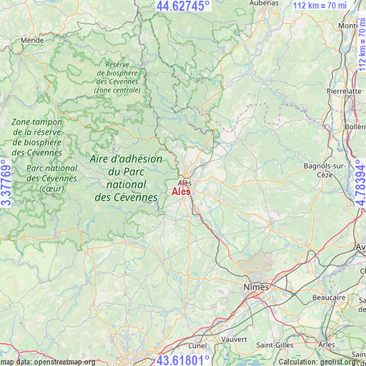
Alès GPS coordinates[2]
44° 7' 29.604" North, 4° 4' 50.952" East
| Map corner | latitude | longitude |
|---|---|---|
| Upper-left | 44.62745°, | 3.37769° |
| Center: | 44.12489°, | 4.08082° |
| Lower-right: | 43.61801°, | 4.78394° |
| Map W x H: | 112.2×112.2 km | = 69.7×69.7mi |
| max Lat: | 51.07786° ⇑86% North |
| Alès: | 44.12489° |
| min Lat: | ⇓14% South 41.3874° |
| min Long | Alès | max Long |
| -5.08615° | 4.08082° | 9.52242° |
| W 68.6%⇐ | ⇒31.4% E |
Elevation
Elevation of Alès is 135 m = 443 ft, and this is 58.7 m = 193 ft below average elevation for this country.
| Max E: |
2333 m = 7654 ft | 49.2% |
| Avg. | 193.7 m = 635 ft | |
| Alès | 135 m = 443 ft | |
Min E: |
-1 m = -3 ft | 50.8% |
See also: Alès elevation on elevation.city.
Geographical zone
Alès is located in North temperate zone (between Tropic of Cancer and the Arctic Circle). Distance of this Northern Tropic circle is 2300.3 km =1429.3 mi to South.| Distance of | km | miles | from Alès |
|---|---|---|---|
| North Pole | 5100.8 | 3169.5 | to North |
| Arctic Circle | 2494.9 | 1550.3 | to North |
| Tropic Cancer | 2300.3 | 1429.3 | to South |
| Equator | 4906.2 | 3048.6 | to South |


Nearby cities:
15 places around Alès: (largest is in red/bold)
• Bagard
6.4 km =4 mi,  200°
200°
• Cendras
3 km =1.9 mi,  337°
337°
• Deaux
8.4 km =5.2 mi,  139°
139°
• Générargues
9.1 km =5.7 mi,  238°
238°
• Laval-Pradel
9.2 km =5.7 mi,  352°
352°
• Mons
7.5 km =4.7 mi,  98°
98°
• Méjannes-lès-Alès
6.6 km =4.1 mi,  116°
116°
• Rousson
9.1 km =5.7 mi,  35°
35°
• Saint-Christol-lès-Alès
4.7 km =2.9 mi,  185°
185°
• Saint-Hilaire-de-Brethmas
6.1 km =3.8 mi, 144°
• Saint-Julien-les-Rosiers
5.9 km =3.7 mi,  21°
21°
• Saint-Martin-de-Valgalgues
4.3 km =2.7 mi,  3°
3°
• Saint-Privat-des-Vieux
4.5 km =2.8 mi,  61°
61°
• Salindres
8.2 km =5.1 mi,  50°
50°
• Vézénobres
9.4 km =5.8 mi,  150°
150°
Sources, notices
• [Note1] Compared only with cities in France existing in our database
• [Src1] Map data: © OpenStreetMap contributors (CC-BY-SA)
• [Src2] Other city data from geonames.org with taken over terms of usage.
• [Src3] Geographical zone / Annual Mean Temperature by Robert A. Rohde @ Wikipedia
