Robiac-Rochessadoule geodata
Robiac-Rochessadoule (Occitanie) is a populated place; located in France in Europe/Paris (GMT+2) time zone. With population of 870 people, there are 9896 cities with bigger population in this country. Compared to other cities in France, 85% of cities are located further ↑North; 69.1% of cities are located further ←West and 69.6% of cities have lower elevation than Robiac-Rochessadoule. Note1
Administrative division(s):
- Level 1: Occitanie
- Level 2: Gard
- Level 3: Arrondissement d’Alès
- Level 4: Robiac-Rochessadoule


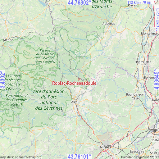
Robiac-Rochessadoule GPS coordinates[2]
44° 16' 0.012" North, 4° 7' 59.988" East
| Map corner | latitude | longitude |
|---|---|---|
| Upper-left | 44.76802°, | 3.4302° |
| Center: | 44.26667°, | 4.13333° |
| Lower-right: | 43.76101°, | 4.83645° |
| Map W x H: | 112×112 km | = 69.6×69.6mi |
| max Lat: | 51.07786° ⇑85% North |
| Robiac-Rochessadoule: | 44.26667° |
| min Lat: | ⇓15% South 41.3874° |
| min Long | Robiac-Rochessa | max Long |
| -5.08615° | 4.13333° | 9.52242° |
| W 69.1%⇐ | ⇒30.9% E |
Elevation
Elevation of Robiac-Rochessadoule is 217 m = 712 ft, and this is 23.3 m = 76 ft above average elevation for this country.
| Max E: |
2333 m = 7654 ft | 30.4% |
| Robiac-Rochessadoule | 217 m 712 ft | |
| Avg. | 193.7 m = 635 ft | |
Min E: |
-1 m = -3 ft | 69.6% |
See also: France elevation on elevation.city.
Geographical zone
Robiac-Rochessadoule is located in North temperate zone (between Tropic of Cancer and the Arctic Circle). Distance of this Northern Tropic circle is 2316.1 km =1439.2 mi to South.| Distance of | km | miles | from Robiac-Rochessadoule |
|---|---|---|---|
| North Pole | 5085.1 | 3159.7 | to North |
| Arctic Circle | 2479.2 | 1540.5 | to North |
| Tropic Cancer | 2316.1 | 1439.2 | to South |
| Equator | 4922 | 3058.4 | to South |


Nearby cities:
15 places around Robiac-Rochessadoule: (largest is in red/bold)
• Bessèges
4.1 km =2.5 mi,  314°
314°
• Gagnières
4.4 km =2.7 mi,  355°
355°
• Laval-Pradel
8.6 km =5.3 mi,  218°
218°
• Le Martinet
4 km =2.5 mi,  242°
242°
• Les Mages
5.1 km =3.2 mi,  145°
145°
• Meyrannes
2.8 km =1.7 mi,  79°
79°
• Molières-sur-Cèze
2.1 km =1.3 mi,  110°
110°
• Rousson
8.5 km =5.3 mi,  172°
172°
• Saint-Ambroix
5.2 km =3.2 mi,  99°
99°
• Saint-André-de-Cruzières
8.5 km =5.3 mi,  51°
51°
• Saint-Florent-sur-Auzonnet
3.4 km =2.1 mi,  209°
209°
• Saint-Jean-de-Valériscle
4.1 km =2.5 mi, 165°
• Saint-Julien-de-Cassagnas
8.2 km =5.1 mi,  140°
140°
• Saint-Paul-le-Jeune
8.3 km =5.2 mi,  11°
11°
• Saint-Victor-de-Malcap
7.2 km =4.5 mi, 103°
Sources, notices
• [Note1] Compared only with cities in France existing in our database
• [Src1] Map data: © OpenStreetMap contributors (CC-BY-SA)
• [Src2] Other city data from geonames.org with taken over terms of usage.
• [Src3] Geographical zone / Annual Mean Temperature by Robert A. Rohde @ Wikipedia
