Laruns geodata
Laruns (Nouvelle-Aquitaine) is a populated place; located in France in Europe/Paris (GMT+2) time zone. With population of 1,546 people, there are 6028 cities with bigger population in this country. Compared to other cities in France, 98.4% of cities are located further ↑North; 82.5% of cities are located further →East and 93.6% of cities have lower elevation than Laruns. Note1
Administrative division(s):
- Level 1: Nouvelle-Aquitaine
- Level 2: Département des Pyrénées-Atlantiques
- Level 3: Oloron-Sainte-Marie
- Level 4: Laruns


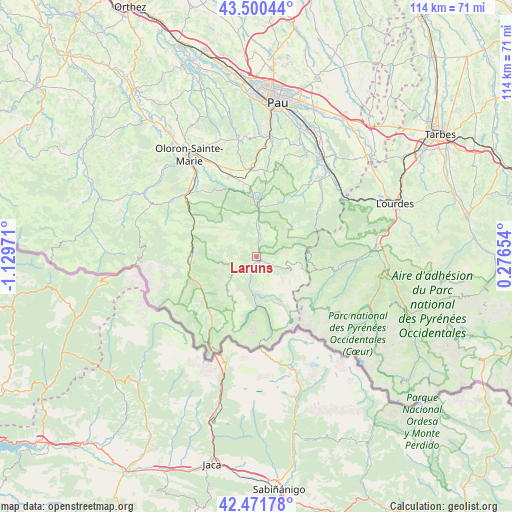
Laruns GPS coordinates[2]
42° 59' 17.736" North, 0° 25' 35.688" West
| Map corner | latitude | longitude |
|---|---|---|
| Upper-left | 43.50044°, | -1.12971° |
| Center: | 42.98826°, | -0.42658° |
| Lower-right: | 42.47178°, | 0.27654° |
| Map W x H: | 114.4×114.4 km | = 71.1×71.1mi |
| max Lat: | 51.07786° ⇑98.4% North |
| Laruns: | 42.98826° |
| min Lat: | ⇓1.6% South 41.3874° |
| min Long | Laruns | max Long |
| -5.08615° | -0.42658° | 9.52242° |
| W 17.5%⇐ | ⇒82.5% E |
Elevation
Elevation of Laruns is 528 m = 1732 ft, and this is 334.3 m = 1097 ft above average elevation for this country.
| Max E: |
2333 m = 7654 ft | 6.4% |
| Laruns | 528 m 1732 ft | |
| Avg. | 193.7 m = 635 ft | |
Min E: |
-1 m = -3 ft | 93.6% |
See also: France elevation on elevation.city.
Geographical zone
Laruns is located in North temperate zone (between Tropic of Cancer and the Arctic Circle). Distance of this Northern Tropic circle is 2173.9 km =1350.8 mi to South.| Distance of | km | miles | from Laruns |
|---|---|---|---|
| North Pole | 5227.2 | 3248 | to North |
| Arctic Circle | 2621.3 | 1628.8 | to North |
| Tropic Cancer | 2173.9 | 1350.8 | to South |
| Equator | 4779.8 | 2970 | to South |


Nearby cities:
15 places around Laruns: (largest is in red/bold)
• Arrens-Marsous
17.6 km =10.9 mi,  103°
103°
• Arthez-d’Asson
17.8 km =11.1 mi,  53°
53°
• Arudy
13.1 km =8.1 mi,  357°
357°
• Asasp-Arros
21 km =13 mi,  312°
312°
• Asson
23 km =14.3 mi,  38°
38°
• Bedous
14.2 km =8.8 mi,  275°
275°
• Bruges-Capbis-Mifaget
19.1 km =11.9 mi,  32°
32°
• Buzy
16.2 km =10.1 mi,  353°
353°
• Eysus
20.6 km =12.8 mi,  321°
321°
• Gurmençon
23.1 km =14.4 mi, 323°
• Lestelle-Bétharram
23.5 km =14.6 mi, 46°
• Louvie-Juzon
10.9 km =6.8 mi,  3°
3°
• Ogeu-les-Bains
18.9 km =11.7 mi,  341°
341°
• Rébénacq
20.1 km =12.5 mi,  10°
10°
• Sévignacq-Meyracq
14 km =8.7 mi, 5°
Sources, notices
• [Note1] Compared only with cities in France existing in our database
• [Src1] Map data: © OpenStreetMap contributors (CC-BY-SA)
• [Src2] Other city data from geonames.org with taken over terms of usage.
• [Src3] Geographical zone / Annual Mean Temperature by Robert A. Rohde @ Wikipedia
