Landrecies geodata
Landrecies (Hauts-de-France) is a populated place; located in France in Europe/Paris (GMT+2) time zone. With population of 4,015 people, there are 2444 cities with bigger population in this country. Compared to other cities in France, 94.4% of cities are located further ↓South; 65.7% of cities are located further ←West and 52.5% of cities have lower elevation than Landrecies. Note1
Administrative division(s):
- Level 1: Hauts-de-France
- Level 2: Nord
- Level 3: Avesnes-sur-Helpe
- Level 4: Landrecies


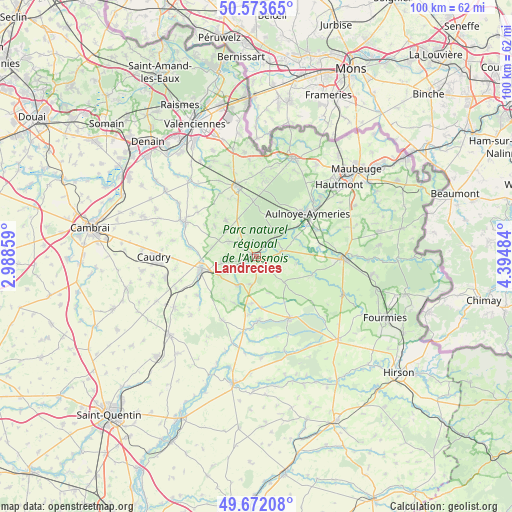
Landrecies GPS coordinates[2]
50° 7' 29.964" North, 3° 41' 30.156" East
| Map corner | latitude | longitude |
|---|---|---|
| Upper-left | 50.57365°, | 2.98859° |
| Center: | 50.12499°, | 3.69171° |
| Lower-right: | 49.67208°, | 4.39484° |
| Map W x H: | 100.2×100.2 km | = 62.3×62.3mi |
| max Lat: | 51.07786° ⇑5.6% North |
| Landrecies: | 50.12499° |
| min Lat: | ⇓94.4% South 41.3874° |
| min Long | Landrecies | max Long |
| -5.08615° | 3.69171° | 9.52242° |
| W 65.7%⇐ | ⇒34.3% E |
Elevation
Elevation of Landrecies is 141 m = 463 ft, and this is 52.7 m = 173 ft below average elevation for this country.
| Max E: |
2333 m = 7654 ft | 47.5% |
| Avg. | 193.7 m = 635 ft | |
| Landrecies | 141 m = 463 ft | |
Min E: |
-1 m = -3 ft | 52.5% |
See also: France elevation on elevation.city.
Geographical zone
Landrecies is located in North temperate zone (between Tropic of Cancer and the Arctic Circle). Distance of this North polar circle is 1827.8 km =1135.7 mi to North.| Distance of | km | miles | from Landrecies |
|---|---|---|---|
| North Pole | 4433.7 | 2755 | to North |
| Arctic Circle | 1827.8 | 1135.7 | to North |
| Tropic Cancer | 2967.5 | 1843.9 | to South |
| Equator | 5573.4 | 3463.1 | to South |


Nearby cities:
15 places around Landrecies: (largest is in red/bold)
• Bazuel
8.1 km =5 mi,  242°
242°
• Bousies
6 km =3.7 mi,  298°
298°
• Cartignies
11.5 km =7.1 mi,  108°
108°
• Catillon-sur-Sambre
6.7 km =4.2 mi,  211°
211°
• Englefontaine
8.1 km =5 mi,  335°
335°
• Fontaine-au-Bois
3.7 km =2.3 mi, 300°
• Forest-en-Cambrésis
8.6 km =5.3 mi,  281°
281°
• Jolimetz
11.5 km =7.1 mi,  354°
354°
• Maroilles
5.1 km =3.2 mi,  77°
77°
• Ors
4.9 km =3 mi, 236°
• Poix-du-Nord
9.2 km =5.7 mi,  320°
320°
• Pommereuil
6.9 km =4.3 mi,  258°
258°
• Preux-au-Bois
5 km =3.1 mi,  331°
331°
• Prisches
7.5 km =4.7 mi,  133°
133°
• Taisnières-en-Thiérache
9.1 km =5.7 mi,  73°
73°
Sources, notices
• [Note1] Compared only with cities in France existing in our database
• [Src1] Map data: © OpenStreetMap contributors (CC-BY-SA)
• [Src2] Other city data from geonames.org with taken over terms of usage.
• [Src3] Geographical zone / Annual Mean Temperature by Robert A. Rohde @ Wikipedia
