Pommereuil geodata
Pommereuil (Hauts-de-France) is a populated place; located in France in Europe/Paris (GMT+2) time zone. With population of 732 people, there are 11386 cities with bigger population in this country. Compared to other cities in France, 94.3% of cities are located further ↓South; 65% of cities are located further ←West and 53.3% of cities have lower elevation than Pommereuil. Note1
Administrative division(s):
- Level 1: Hauts-de-France
- Level 2: Nord
- Level 3: Arrondissement de Cambrai
- Level 4: Pommereuil


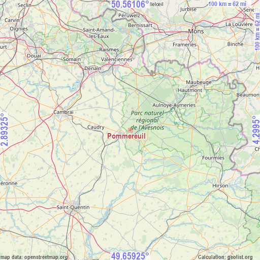
Pommereuil GPS coordinates[2]
50° 6' 44.208" North, 3° 35' 46.932" East
| Map corner | latitude | longitude |
|---|---|---|
| Upper-left | 50.56106°, | 2.89325° |
| Center: | 50.11228°, | 3.59637° |
| Lower-right: | 49.65925°, | 4.2995° |
| Map W x H: | 100.3×100.3 km | = 62.3×62.3mi |
| max Lat: | 51.07786° ⇑5.7% North |
| Pommereuil: | 50.11228° |
| min Lat: | ⇓94.3% South 41.3874° |
| min Long | Pommereuil | max Long |
| -5.08615° | 3.59637° | 9.52242° |
| W 65%⇐ | ⇒35% E |
Elevation
Elevation of Pommereuil is 144 m = 472 ft, and this is 49.7 m = 163 ft below average elevation for this country.
| Max E: |
2333 m = 7654 ft | 46.7% |
| Avg. | 193.7 m = 635 ft | |
| Pommereuil | 144 m = 472 ft | |
Min E: |
-1 m = -3 ft | 53.3% |
See also: France elevation on elevation.city.
Geographical zone
Pommereuil is located in North temperate zone (between Tropic of Cancer and the Arctic Circle). Distance of this North polar circle is 1829.2 km =1136.6 mi to North.| Distance of | km | miles | from Pommereuil |
|---|---|---|---|
| North Pole | 4435.1 | 2755.8 | to North |
| Arctic Circle | 1829.2 | 1136.6 | to North |
| Tropic Cancer | 2966 | 1843 | to South |
| Equator | 5572 | 3462.3 | to South |


Nearby cities:
15 places around Pommereuil: (largest is in red/bold)
• Bazuel
2.4 km =1.5 mi,  188°
188°
• Bousies
4.6 km =2.9 mi,  19°
19°
• Briastre
9.6 km =6 mi,  304°
304°
• Catillon-sur-Sambre
5.4 km =3.4 mi,  142°
142°
• Englefontaine
9.4 km =5.8 mi, 21°
• Fontaine-au-Bois
4.9 km =3 mi,  47°
47°
• Forest-en-Cambrésis
3.5 km =2.2 mi,  331°
331°
• Inchy
9.5 km =5.9 mi,  276°
276°
• Landrecies
6.9 km =4.3 mi,  78°
78°
• Neuvilly
6.8 km =4.2 mi, 300°
• Ors
3 km =1.9 mi,  115°
115°
• Poix-du-Nord
8.6 km =5.3 mi,  6°
6°
• Preux-au-Bois
7.3 km =4.5 mi,  37°
37°
• Saint-Souplet
7.7 km =4.8 mi,  216°
216°
• Troisvilles
9.1 km =5.7 mi,  264°
264°
Sources, notices
• [Note1] Compared only with cities in France existing in our database
• [Src1] Map data: © OpenStreetMap contributors (CC-BY-SA)
• [Src2] Other city data from geonames.org with taken over terms of usage.
• [Src3] Geographical zone / Annual Mean Temperature by Robert A. Rohde @ Wikipedia
