La Guiche geodata
La Guiche (Bourgogne-Franche-Comté) is a populated place; located in France in Europe/Paris (GMT+2) time zone. With population of 647 people, there are 12562 cities with bigger population in this country. Compared to other cities in France, 59.7% of cities are located further ↑North; 71.7% of cities are located further ←West and 90% of cities have lower elevation than La Guiche. Note1
Administrative division(s):
- Level 1: Bourgogne-Franche-Comté
- Level 2: Département de Saône-et-Loire
- Level 3: Arrondissement de Mâcon
- Level 4: La Guiche


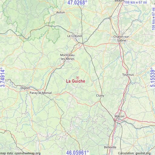
La Guiche GPS coordinates[2]
46° 32' 43.296" North, 4° 27' 8.136" East
| Map corner | latitude | longitude |
|---|---|---|
| Upper-left | 47.0268°, | 3.74914° |
| Center: | 46.54536°, | 4.45226° |
| Lower-right: | 46.05961°, | 5.15539° |
| Map W x H: | 107.5×107.5 km | = 66.8×66.8mi |
| max Lat: | 51.07786° ⇑59.7% North |
| La Guiche: | 46.54536° |
| min Lat: | ⇓40.3% South 41.3874° |
| min Long | La Guiche | max Long |
| -5.08615° | 4.45226° | 9.52242° |
| W 71.7%⇐ | ⇒28.3% E |
Elevation
Elevation of La Guiche is 426 m = 1398 ft, and this is 232.3 m = 762 ft above average elevation for this country.
| Max E: |
2333 m = 7654 ft | 10% |
| La Guiche | 426 m 1398 ft | |
| Avg. | 193.7 m = 635 ft | |
Min E: |
-1 m = -3 ft | 90% |
See also: France elevation on elevation.city.
Geographical zone
La Guiche is located in North temperate zone (between Tropic of Cancer and the Arctic Circle). Distance of this North polar circle is 2225.8 km =1383 mi to North.| Distance of | km | miles | from La Guiche |
|---|---|---|---|
| North Pole | 4831.7 | 3002.3 | to North |
| Arctic Circle | 2225.8 | 1383 | to North |
| Tropic Cancer | 2569.4 | 1596.6 | to South |
| Equator | 5175.4 | 3215.8 | to South |


Nearby cities:
15 places around La Guiche: (largest is in red/bold)
• Blanzy
17.9 km =11.1 mi,  344°
344°
• Charolles
18.3 km =11.4 mi,  227°
227°
• Ciry-le-Noble
13.5 km =8.4 mi,  299°
299°
• Gourdon
10.7 km =6.6 mi,  357°
357°
• Génelard
17 km =10.6 mi,  283°
283°
• Montceau-les-Mines
15 km =9.3 mi,  334°
334°
• Palinges
17.8 km =11.1 mi,  272°
272°
• Pouilloux
9.9 km =6.2 mi,  314°
314°
• Saint-Bonnet-de-Joux
7.1 km =4.4 mi,  188°
188°
• Saint-Gengoux-le-National
17.8 km =11.1 mi,  64°
64°
• Saint-Vallier
12.3 km =7.6 mi, 329°
• Salornay-sur-Guye
11.4 km =7.1 mi,  104°
104°
• Sanvignes-les-Mines
18 km =11.2 mi,  317°
317°
• Vendenesse-lès-Charolles
14.4 km =8.9 mi,  217°
217°
• Verosvres
16.2 km =10.1 mi, 185°
Sources, notices
• [Note1] Compared only with cities in France existing in our database
• [Src1] Map data: © OpenStreetMap contributors (CC-BY-SA)
• [Src2] Other city data from geonames.org with taken over terms of usage.
• [Src3] Geographical zone / Annual Mean Temperature by Robert A. Rohde @ Wikipedia
