Saint-Gengoux-le-National geodata
Saint-Gengoux-le-National (Bourgogne-Franche-Comté) is a populated place; located in France in Europe/Paris (GMT+2) time zone. With population of 1,059 people, there are 8406 cities with bigger population in this country. Compared to other cities in France, 59.1% of cities are located further ↑North; 73.4% of cities are located further ←West and 73.2% of cities have lower elevation than Saint-Gengoux-le-National. Note1
Administrative division(s):
- Level 1: Bourgogne-Franche-Comté
- Level 2: Département de Saône-et-Loire
- Level 3: Arrondissement de Chalon-sur-Saône
- Level 4: Saint-Gengoux-le-National
Current local time in Saint-Gengoux-le-National:
01:16 PM, SaturdayDifference from your time zone: hours


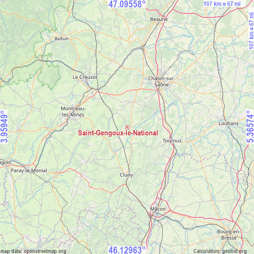
Saint-Gengoux-le-National GPS coordinates[2]
46° 36' 53.136" North, 4° 39' 45.396" East
| Map corner | latitude | longitude |
|---|---|---|
| Upper-left | 47.09558°, | 3.95949° |
| Center: | 46.61476°, | 4.66261° |
| Lower-right: | 46.12963°, | 5.36574° |
| Map W x H: | 107.4×107.4 km | = 66.7×66.7mi |
| max Lat: | 51.07786° ⇑59.1% North |
| Saint-Gengoux-le-National: | 46.61476° |
| min Lat: | ⇓40.9% South 41.3874° |
| min Long | Saint-Gengoux-l | max Long |
| -5.08615° | 4.66261° | 9.52242° |
| W 73.4%⇐ | ⇒26.6% E |
Elevation
Elevation of Saint-Gengoux-le-National is 237 m = 778 ft, and this is 43.3 m = 142 ft above average elevation for this country.
| Max E: |
2333 m = 7654 ft | 26.8% |
| Saint-Gengoux-le-National | 237 m 778 ft | |
| Avg. | 193.7 m = 635 ft | |
Min E: |
-1 m = -3 ft | 73.2% |
See also: France elevation on elevation.city.
Geographical zone
Saint-Gengoux-le-National is located in North temperate zone (between Tropic of Cancer and the Arctic Circle). Distance of this North polar circle is 2218.1 km =1378.3 mi to North.| Distance of | km | miles | from Saint-Gengoux-le-National |
|---|---|---|---|
| North Pole | 4824 | 2997.5 | to North |
| Arctic Circle | 2218.1 | 1378.3 | to North |
| Tropic Cancer | 2577.2 | 1601.4 | to South |
| Equator | 5183.1 | 3220.6 | to South |


Nearby cities:
15 places around Saint-Gengoux-le-National: (largest is in red/bold)
• Boyer
17.1 km =10.6 mi,  98°
98°
• Buxy
11.5 km =7.1 mi,  16°
16°
• Gourdon
16.8 km =10.4 mi,  280°
280°
• La Charmée
15.5 km =9.6 mi,  40°
40°
• La Guiche
17.8 km =11.1 mi,  244°
244°
• Laives
14.2 km =8.8 mi,  76°
76°
• Messey-sur-Grosne
7 km =4.3 mi,  62°
62°
• Moroges
15.2 km =9.4 mi,  4°
4°
• Nanton
11.8 km =7.3 mi,  87°
87°
• Plottes
18.7 km =11.6 mi,  120°
120°
• Saint-Désert
16 km =9.9 mi,  13°
13°
• Saint-Leu
17.8 km =11.1 mi,  316°
316°
• Salornay-sur-Guye
11.6 km =7.2 mi,  205°
205°
• Sennecey-le-Grand
15.9 km =9.9 mi, 79°
• Écuisses
18.4 km =11.4 mi,  328°
328°
Sources, notices
• [Note1] Compared only with cities in France existing in our database
• [Src1] Map data: © OpenStreetMap contributors (CC-BY-SA)
• [Src2] Other city data from geonames.org with taken over terms of usage.
• [Src3] Geographical zone / Annual Mean Temperature by Robert A. Rohde @ Wikipedia
