Palinges geodata
Palinges (Bourgogne-Franche-Comté) is a populated place; located in France in Europe/Paris (GMT+1) time zone. With population of 1,522 people, there are 6112 cities with bigger population in this country. Compared to other cities in France, 59.7% of cities are located further ↑North; 69.9% of cities are located further ←West and 78.3% of cities have lower elevation than Palinges. Note1
Administrative division(s):
- Level 1: Bourgogne-Franche-Comté
- Level 2: Département de Saône-et-Loire
- Level 3: Arrondissement de Charolles
- Level 4: Palinges


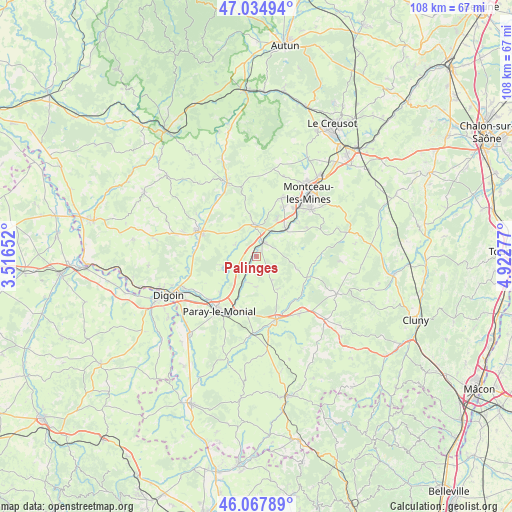
Palinges GPS coordinates[2]
46° 33' 12.852" North, 4° 13' 10.704" East
| Map corner | latitude | longitude |
|---|---|---|
| Upper-left | 47.03494°, | 3.51652° |
| Center: | 46.55357°, | 4.21964° |
| Lower-right: | 46.06789°, | 4.92277° |
| Map W x H: | 107.5×107.5 km | = 66.8×66.8mi |
| max Lat: | 51.07786° ⇑59.7% North |
| Palinges: | 46.55357° |
| min Lat: | ⇓40.3% South 41.3874° |
| min Long | Palinges | max Long |
| -5.08615° | 4.21964° | 9.52242° |
| W 69.9%⇐ | ⇒30.1% E |
Elevation
Elevation of Palinges is 274 m = 899 ft, and this is 80.3 m = 263 ft above average elevation for this country.
| Max E: |
2333 m = 7654 ft | 21.7% |
| Palinges | 274 m 899 ft | |
| Avg. | 193.7 m = 635 ft | |
Min E: |
-1 m = -3 ft | 78.3% |
See also: France elevation on elevation.city.
Geographical zone
Palinges is located in North temperate zone (between Tropic of Cancer and the Arctic Circle). Distance of this North polar circle is 2224.9 km =1382.5 mi to North.| Distance of | km | miles | from Palinges |
|---|---|---|---|
| North Pole | 4830.8 | 3001.7 | to North |
| Arctic Circle | 2224.9 | 1382.5 | to North |
| Tropic Cancer | 2570.4 | 1597.2 | to South |
| Equator | 5176.3 | 3216.4 | to South |


Nearby cities:
15 places around Palinges: (largest is in red/bold)
• Charolles
13.9 km =8.6 mi,  162°
162°
• Ciry-le-Noble
8.4 km =5.2 mi,  45°
45°
• Gueugnon
13.2 km =8.2 mi,  294°
294°
• Génelard
3.3 km =2.1 mi,  22°
22°
• Montceau-les-Mines
16.9 km =10.5 mi,  41°
41°
• Paray-le-Monial
13.6 km =8.5 mi,  215°
215°
• Perrecy-les-Forges
6.8 km =4.2 mi,  356°
356°
• Pouilloux
12.3 km =7.6 mi,  60°
60°
• Rigny-sur-Arroux
14.8 km =9.2 mi,  260°
260°
• Saint-Vallier
15.1 km =9.4 mi, 49°
• Sanvignes-les-Mines
13.5 km =8.4 mi, 24°
• Toulon-sur-Arroux
16.7 km =10.4 mi,  338°
338°
• Vendenesse-lès-Charolles
15.3 km =9.5 mi,  143°
143°
• Vendenesse-sur-Arroux
14.4 km =8.9 mi,  304°
304°
• Volesvres
10.2 km =6.3 mi,  206°
206°
Sources, notices
• [Note1] Compared only with cities in France existing in our database
• [Src1] Map data: © OpenStreetMap contributors (CC-BY-SA)
• [Src2] Other city data from geonames.org with taken over terms of usage.
• [Src3] Geographical zone / Annual Mean Temperature by Robert A. Rohde @ Wikipedia
