Laguépie geodata
Laguépie (Occitanie) is a populated place; located in France in Europe/Paris (GMT+2) time zone. With population of 770 people, there are 10937 cities with bigger population in this country. Compared to other cities in France, 85.9% of cities are located further ↑North; 57.5% of cities are located further →East and 64% of cities have lower elevation than Laguépie. Note1
Administrative division(s):
- Level 1: Occitanie
- Level 2: Département du Tarn-et-Garonne
- Level 3: Arrondissement de Montauban
- Level 4: Laguépie


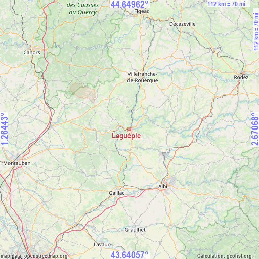
Laguépie GPS coordinates[2]
44° 8' 50.1" North, 1° 58' 3.216" East
| Map corner | latitude | longitude |
|---|---|---|
| Upper-left | 44.64962°, | 1.26443° |
| Center: | 44.14725°, | 1.96756° |
| Lower-right: | 43.64057°, | 2.67068° |
| Map W x H: | 112.2×112.2 km | = 69.7×69.7mi |
| max Lat: | 51.07786° ⇑85.9% North |
| Laguépie: | 44.14725° |
| min Lat: | ⇓14.1% South 41.3874° |
| min Long | Laguépie | max Long |
| -5.08615° | 1.96756° | 9.52242° |
| W 42.5%⇐ | ⇒57.5% E |
Elevation
Elevation of Laguépie is 189 m = 620 ft, and this is 4.7 m = 15 ft below average elevation for this country.
| Max E: |
2333 m = 7654 ft | 36% |
| Avg. | 193.7 m = 635 ft | |
| Laguépie | 189 m = 620 ft | |
Min E: |
-1 m = -3 ft | 64% |
See also: France elevation on elevation.city.
Geographical zone
Laguépie is located in North temperate zone (between Tropic of Cancer and the Arctic Circle). Distance of this Northern Tropic circle is 2302.8 km =1430.9 mi to South.| Distance of | km | miles | from Laguépie |
|---|---|---|---|
| North Pole | 5098.3 | 3167.9 | to North |
| Arctic Circle | 2492.5 | 1548.8 | to North |
| Tropic Cancer | 2302.8 | 1430.9 | to South |
| Equator | 4908.7 | 3050.1 | to South |


Nearby cities:
15 places around Laguépie: (largest is in red/bold)
• Blaye-les-Mines
18.4 km =11.4 mi,  134°
134°
• Cahuzac-sur-Vère
18.9 km =11.7 mi,  193°
193°
• Carmaux
18.6 km =11.6 mi, 125°
• Caylus
18.5 km =11.5 mi,  302°
302°
• Cordes-sur-Ciel
9.1 km =5.7 mi, 188°
• La Fouillade
10.9 km =6.8 mi,  31°
31°
• La Rouquette
17.2 km =10.7 mi,  1°
1°
• Mirandol-Bourgnounac
16 km =9.9 mi,  91°
91°
• Monestiés
13.9 km =8.6 mi, 130°
• Monteils
13.4 km =8.3 mi,  10°
10°
• Najac
8 km =5 mi, 5°
• Saint-Benoît-de-Carmaux
16.8 km =10.4 mi, 129°
• Sanvensa
17.3 km =10.7 mi,  22°
22°
• Vailhourles
18.2 km =11.3 mi,  344°
344°
• Varen
6 km =3.7 mi,  282°
282°
Sources, notices
• [Note1] Compared only with cities in France existing in our database
• [Src1] Map data: © OpenStreetMap contributors (CC-BY-SA)
• [Src2] Other city data from geonames.org with taken over terms of usage.
• [Src3] Geographical zone / Annual Mean Temperature by Robert A. Rohde @ Wikipedia
