Carmaux geodata
Carmaux (Occitanie) is a populated place; located in France in Europe/Paris (GMT+2) time zone. With population of 10,413 people, there are 911 cities with bigger population in this country. Compared to other cities in France, 86.7% of cities are located further ↑North; 55.1% of cities are located further →East and 74.4% of cities have lower elevation than Carmaux. Note1


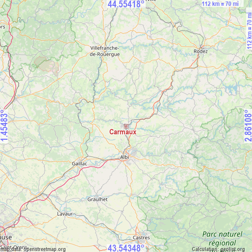
Carmaux GPS coordinates[2]
44° 3' 3.564" North, 2° 9' 28.62" East
| Map corner | latitude | longitude |
|---|---|---|
| Upper-left | 44.55418°, | 1.45483° |
| Center: | 44.05099°, | 2.15795° |
| Lower-right: | 43.54348°, | 2.86108° |
| Map W x H: | 112.4×112.4 km | = 69.8×69.8mi |
| max Lat: | 51.07786° ⇑86.7% North |
| Carmaux: | 44.05099° |
| min Lat: | ⇓13.3% South 41.3874° |
| min Long | Carmaux | max Long |
| -5.08615° | 2.15795° | 9.52242° |
| W 44.9%⇐ | ⇒55.1% E |
Elevation
Elevation of Carmaux is 245 m = 804 ft, and this is 51.3 m = 168 ft above average elevation for this country.
| Max E: |
2333 m = 7654 ft | 25.6% |
| Carmaux | 245 m 804 ft | |
| Avg. | 193.7 m = 635 ft | |
Min E: |
-1 m = -3 ft | 74.4% |
See also: France elevation on elevation.city.
Geographical zone
Carmaux is located in North temperate zone (between Tropic of Cancer and the Arctic Circle). Distance of this Northern Tropic circle is 2292.1 km =1424.2 mi to South.| Distance of | km | miles | from Carmaux |
|---|---|---|---|
| North Pole | 5109.1 | 3174.6 | to North |
| Arctic Circle | 2503.2 | 1555.4 | to North |
| Tropic Cancer | 2292.1 | 1424.2 | to South |
| Equator | 4898 | 3043.5 | to South |


Nearby cities:
15 places around Carmaux: (largest is in red/bold)
• Albi
13.5 km =8.4 mi,  183°
183°
• Arthès
11.2 km =7 mi,  157°
157°
• Blaye-les-Mines
3.1 km =1.9 mi,  223°
223°
• Cagnac-les-Mines
7.5 km =4.7 mi,  189°
189°
• Castelnau-de-Lévis
13.7 km =8.5 mi,  205°
205°
• Le Garric
4.7 km =2.9 mi,  173°
173°
• Mirandol-Bourgnounac
10.2 km =6.3 mi,  4°
4°
• Monestiés
4.9 km =3 mi,  290°
290°
• Pampelonne
10.7 km =6.6 mi,  40°
40°
• Rosières
2 km =1.2 mi,  111°
111°
• Saint-Benoît-de-Carmaux
2.3 km =1.4 mi,  268°
268°
• Saint-Juéry
12.2 km =7.6 mi, 157°
• Sainte-Gemme
5.5 km =3.4 mi, 39°
• Tanus
13.9 km =8.6 mi,  66°
66°
• Valderiès
7.4 km =4.6 mi,  126°
126°
Sources, notices
• [Note1] Compared only with cities in France existing in our database
• [Src1] Map data: © OpenStreetMap contributors (CC-BY-SA)
• [Src2] Other city data from geonames.org with taken over terms of usage.
• [Src3] Geographical zone / Annual Mean Temperature by Robert A. Rohde @ Wikipedia
