Ladon geodata
Ladon (Centre) is a populated place; located in France in Europe/Paris (GMT+2) time zone. With population of 1,203 people, there are 7511 cities with bigger population in this country. Compared to other cities in France, 59.3% of cities are located further ↓South; 51.2% of cities are located further ←West and 61.5% of cities have higher elevation than Ladon. Note1
Administrative division(s):
- Level 1: Centre
- Level 2: Loiret
- Level 3: Arrondissement de Montargis
- Level 4: Ladon


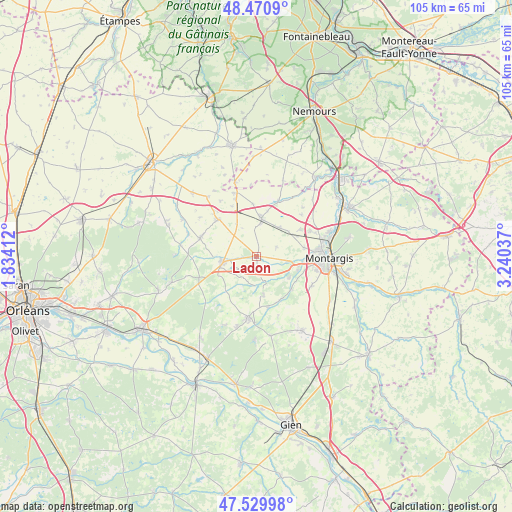
Ladon GPS coordinates[2]
48° 0' 9.324" North, 2° 32' 14.064" East
| Map corner | latitude | longitude |
|---|---|---|
| Upper-left | 48.4709°, | 1.83412° |
| Center: | 48.00259°, | 2.53724° |
| Lower-right: | 47.52998°, | 3.24037° |
| Map W x H: | 104.6×104.6 km | = 65×65mi |
| max Lat: | 51.07786° ⇑40.7% North |
| Ladon: | 48.00259° |
| min Lat: | ⇓59.3% South 41.3874° |
| min Long | Ladon | max Long |
| -5.08615° | 2.53724° | 9.52242° |
| W 51.2%⇐ | ⇒48.8% E |
Elevation
Elevation of Ladon is 98 m = 322 ft, and this is 95.7 m = 314 ft below average elevation for this country.
| Max E: |
2333 m = 7654 ft | 61.5% |
| Avg. | 193.7 m = 635 ft | |
| Ladon | 98 m = 322 ft | |
Min E: |
-1 m = -3 ft | 38.5% |
See also: France elevation on elevation.city.
Geographical zone
Ladon is located in North temperate zone (between Tropic of Cancer and the Arctic Circle). Distance of this North polar circle is 2063.8 km =1282.4 mi to North.| Distance of | km | miles | from Ladon |
|---|---|---|---|
| North Pole | 4669.7 | 2901.6 | to North |
| Arctic Circle | 2063.8 | 1282.4 | to North |
| Tropic Cancer | 2731.5 | 1697.3 | to South |
| Equator | 5337.4 | 3316.5 | to South |


Nearby cities:
15 places around Ladon: (largest is in red/bold)
• Beaune-la-Rolande
11 km =6.8 mi,  314°
314°
• Bellegarde
8 km =5 mi,  254°
254°
• Boiscommun
12 km =7.5 mi,  287°
287°
• Chailly-en-Gâtinais
6.2 km =3.9 mi,  175°
175°
• Chevillon-sur-Huillard
8 km =5 mi,  124°
124°
• Corbeilles
7.8 km =4.8 mi,  7°
7°
• Lorcy
5.8 km =3.6 mi,  355°
355°
• Noyers
9.9 km =6.2 mi,  185°
185°
• Pannes
9.9 km =6.2 mi,  79°
79°
• Quiers-sur-Bézonde
7.2 km =4.5 mi,  264°
264°
• Saint-Maurice-sur-Fessard
6.4 km =4 mi,  100°
100°
• Sceaux-du-Gâtinais
12.3 km =7.6 mi,  20°
20°
• Thimory
10.1 km =6.3 mi,  151°
151°
• Villemoutiers
1.8 km =1.1 mi, 116°
• Vimory
12.7 km =7.9 mi, 118°
Sources, notices
• [Note1] Compared only with cities in France existing in our database
• [Src1] Map data: © OpenStreetMap contributors (CC-BY-SA)
• [Src2] Other city data from geonames.org with taken over terms of usage.
• [Src3] Geographical zone / Annual Mean Temperature by Robert A. Rohde @ Wikipedia
