Chevillon-sur-Huillard geodata
Chevillon-sur-Huillard (Centre) is a populated place; located in France in Europe/Paris (GMT+2) time zone. With population of 1,201 people, there are 7527 cities with bigger population in this country. Compared to other cities in France, 58.6% of cities are located further ↓South; 52.5% of cities are located further ←West and 61.2% of cities have higher elevation than Chevillon-sur-Huillard. Note1
Administrative division(s):
- Level 1: Centre
- Level 2: Loiret
- Level 3: Arrondissement de Montargis
- Level 4: Chevillon-sur-Huillard
Current local time in Chevillon-sur-Huillard:
02:51 AM, WednesdayDifference from your time zone: hours


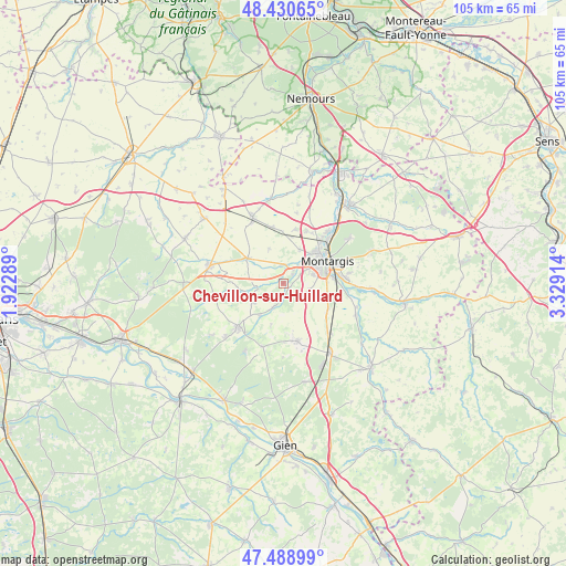
Chevillon-sur-Huillard GPS coordinates[2]
47° 57' 43.092" North, 2° 37' 33.636" East
| Map corner | latitude | longitude |
|---|---|---|
| Upper-left | 48.43065°, | 1.92289° |
| Center: | 47.96197°, | 2.62601° |
| Lower-right: | 47.48899°, | 3.32914° |
| Map W x H: | 104.7×104.7 km | = 65.1×65.1mi |
| max Lat: | 51.07786° ⇑41.4% North |
| Chevillon-sur-Huillard: | 47.96197° |
| min Lat: | ⇓58.6% South 41.3874° |
| min Long | Chevillon-sur-H | max Long |
| -5.08615° | 2.62601° | 9.52242° |
| W 52.5%⇐ | ⇒47.5% E |
Elevation
Elevation of Chevillon-sur-Huillard is 99 m = 325 ft, and this is 94.7 m = 311 ft below average elevation for this country.
| Max E: |
2333 m = 7654 ft | 61.2% |
| Avg. | 193.7 m = 635 ft | |
| Chevillon-sur-Huillard | 99 m = 325 ft | |
Min E: |
-1 m = -3 ft | 38.8% |
See also: France elevation on elevation.city.
Geographical zone
Chevillon-sur-Huillard is located in North temperate zone (between Tropic of Cancer and the Arctic Circle). Distance of this North polar circle is 2068.3 km =1285.2 mi to North.| Distance of | km | miles | from Chevillon-sur-Huillard |
|---|---|---|---|
| North Pole | 4674.2 | 2904.4 | to North |
| Arctic Circle | 2068.3 | 1285.2 | to North |
| Tropic Cancer | 2727 | 1694.5 | to South |
| Equator | 5332.9 | 3313.7 | to South |


Nearby cities:
15 places around Chevillon-sur-Huillard: (largest is in red/bold)
• Amilly
10.9 km =6.8 mi,  83°
83°
• Chailly-en-Gâtinais
6.4 km =4 mi,  254°
254°
• Changy-les-Bois
12.4 km =7.7 mi,  159°
159°
• Châlette-sur-Loing
10 km =6.2 mi,  55°
55°
• Corquilleroy
10.6 km =6.6 mi,  33°
33°
• Ladon
8 km =5 mi,  304°
304°
• Lorris
11.6 km =7.2 mi,  225°
225°
• Montargis
8.8 km =5.5 mi, 63°
• Noyers
9.3 km =5.8 mi,  235°
235°
• Pannes
7.1 km =4.4 mi, 25°
• Saint-Maurice-sur-Fessard
3.4 km =2.1 mi,  354°
354°
• Thimory
4.8 km =3 mi,  202°
202°
• Villemandeur
7.4 km =4.6 mi,  67°
67°
• Villemoutiers
6.2 km =3.9 mi,  306°
306°
• Vimory
4.8 km =3 mi,  109°
109°
Sources, notices
• [Note1] Compared only with cities in France existing in our database
• [Src1] Map data: © OpenStreetMap contributors (CC-BY-SA)
• [Src2] Other city data from geonames.org with taken over terms of usage.
• [Src3] Geographical zone / Annual Mean Temperature by Robert A. Rohde @ Wikipedia
