Noyers geodata
Noyers (Centre) is a populated place; located in France in Europe/Paris (GMT+2) time zone. With population of 714 people, there are 11603 cities with bigger population in this country. Compared to other cities in France, 57.8% of cities are located further ↓South; 51% of cities are located further ←West and 57.3% of cities have higher elevation than Noyers. Note1
Administrative division(s):
- Level 1: Centre
- Level 2: Loiret
- Level 3: Arrondissement de Montargis
- Level 4: Noyers


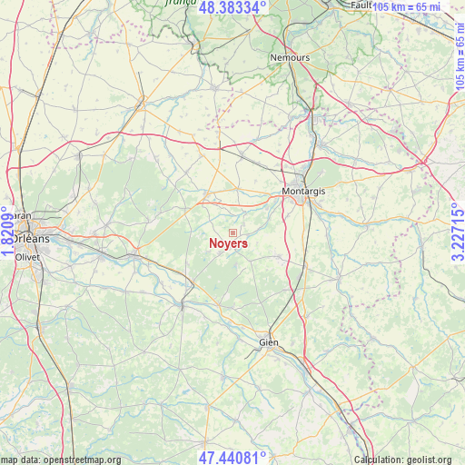
Noyers GPS coordinates[2]
47° 54' 51.192" North, 2° 31' 26.472" East
| Map corner | latitude | longitude |
|---|---|---|
| Upper-left | 48.38334°, | 1.8209° |
| Center: | 47.91422°, | 2.52402° |
| Lower-right: | 47.44081°, | 3.22715° |
| Map W x H: | 104.8×104.8 km | = 65.1×65.1mi |
| max Lat: | 51.07786° ⇑42.2% North |
| Noyers: | 47.91422° |
| min Lat: | ⇓57.8% South 41.3874° |
| min Long | Noyers | max Long |
| -5.08615° | 2.52402° | 9.52242° |
| W 51%⇐ | ⇒49% E |
Elevation
Elevation of Noyers is 110 m = 361 ft, and this is 83.7 m = 275 ft below average elevation for this country.
| Max E: |
2333 m = 7654 ft | 57.3% |
| Avg. | 193.7 m = 635 ft | |
| Noyers | 110 m = 361 ft | |
Min E: |
-1 m = -3 ft | 42.7% |
See also: France elevation on elevation.city.
Geographical zone
Noyers is located in North temperate zone (between Tropic of Cancer and the Arctic Circle). Distance of this North polar circle is 2073.6 km =1288.5 mi to North.| Distance of | km | miles | from Noyers |
|---|---|---|---|
| North Pole | 4679.5 | 2907.7 | to North |
| Arctic Circle | 2073.6 | 1288.5 | to North |
| Tropic Cancer | 2721.6 | 1691.1 | to South |
| Equator | 5327.6 | 3310.4 | to South |


Nearby cities:
15 places around Noyers: (largest is in red/bold)
• Bellegarde
10.2 km =6.3 mi,  318°
318°
• Bouzy-la-Forêt
13 km =8.1 mi,  237°
237°
• Bray-en-Val
15.1 km =9.4 mi,  230°
230°
• Chailly-en-Gâtinais
3.9 km =2.4 mi,  21°
21°
• Changy-les-Bois
13.6 km =8.5 mi,  117°
117°
• Chevillon-sur-Huillard
9.3 km =5.8 mi,  55°
55°
• Ladon
9.9 km =6.2 mi,  5°
5°
• Lorris
2.8 km =1.7 mi,  194°
194°
• Montereau
7.4 km =4.6 mi,  150°
150°
• Quiers-sur-Bézonde
11 km =6.8 mi,  325°
325°
• Saint-Maurice-sur-Fessard
11.3 km =7 mi,  39°
39°
• Sury-aux-Bois
14.8 km =9.2 mi,  293°
293°
• Thimory
5.8 km =3.6 mi,  80°
80°
• Villemoutiers
9.4 km =5.8 mi, 16°
• Vimory
12.7 km =7.9 mi,  72°
72°
Sources, notices
• [Note1] Compared only with cities in France existing in our database
• [Src1] Map data: © OpenStreetMap contributors (CC-BY-SA)
• [Src2] Other city data from geonames.org with taken over terms of usage.
• [Src3] Geographical zone / Annual Mean Temperature by Robert A. Rohde @ Wikipedia
