La Bussière geodata
La Bussière (Centre) is a populated place; located in France in Europe/Paris (GMT+2) time zone. With population of 781 people, there are 10811 cities with bigger population in this country. Compared to other cities in France, 55% of cities are located further ↓South; 54.3% of cities are located further ←West and 57.4% of cities have lower elevation than La Bussière. Note1
Administrative division(s):
- Level 1: Centre
- Level 2: Loiret
- Level 3: Arrondissement de Montargis
- Level 4: La Bussière


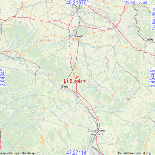
La Bussière GPS coordinates[2]
47° 44' 45.96" North, 2° 45' 5.472" East
| Map corner | latitude | longitude |
|---|---|---|
| Upper-left | 48.21675°, | 2.0484° |
| Center: | 47.7461°, | 2.75152° |
| Lower-right: | 47.27116°, | 3.45465° |
| Map W x H: | 105.1×105.1 km | = 65.3×65.3mi |
| max Lat: | 51.07786° ⇑45% North |
| La Bussière: | 47.7461° |
| min Lat: | ⇓55% South 41.3874° |
| min Long | La Bussière | max Long |
| -5.08615° | 2.75152° | 9.52242° |
| W 54.3%⇐ | ⇒45.7% E |
Elevation
Elevation of La Bussière is 159 m = 522 ft, and this is 34.7 m = 114 ft below average elevation for this country.
| Max E: |
2333 m = 7654 ft | 42.6% |
| Avg. | 193.7 m = 635 ft | |
| La Bussière | 159 m = 522 ft | |
Min E: |
-1 m = -3 ft | 57.4% |
See also: France elevation on elevation.city.
Geographical zone
La Bussière is located in North temperate zone (between Tropic of Cancer and the Arctic Circle). Distance of this North polar circle is 2092.3 km =1300.1 mi to North.| Distance of | km | miles | from La Bussière |
|---|---|---|---|
| North Pole | 4698.2 | 2919.3 | to North |
| Arctic Circle | 2092.3 | 1300.1 | to North |
| Tropic Cancer | 2702.9 | 1679.5 | to South |
| Equator | 5308.9 | 3298.8 | to South |


Nearby cities:
15 places around La Bussière: (largest is in red/bold)
• Boismorand
5.1 km =3.2 mi,  331°
331°
• Briare
12.5 km =7.8 mi,  182°
182°
• Changy-les-Bois
13.4 km =8.3 mi,  338°
338°
• Châtillon-Coligny
11 km =6.8 mi,  39°
39°
• Dammarie-sur-Loing
10.5 km =6.5 mi,  66°
66°
• Gien
10.8 km =6.7 mi,  236°
236°
• Montbouy
13.7 km =8.5 mi,  21°
21°
• Nevoy
13.4 km =8.3 mi,  255°
255°
• Nogent-sur-Vernisson
11.1 km =6.9 mi,  356°
356°
• Ouzouer-sur-Trézée
9.2 km =5.7 mi,  152°
152°
• Rogny-les-Sept-Écluses
9.9 km =6.2 mi,  87°
87°
• Saint-Brisson-sur-Loire
12.2 km =7.6 mi,  205°
205°
• Saint-Firmin-sur-Loire
13.5 km =8.4 mi,  186°
186°
• Saint-Martin-sur-Ocre
11.9 km =7.4 mi,  215°
215°
• Sainte-Geneviève-des-Bois
9.3 km =5.8 mi,  31°
31°
Sources, notices
• [Note1] Compared only with cities in France existing in our database
• [Src1] Map data: © OpenStreetMap contributors (CC-BY-SA)
• [Src2] Other city data from geonames.org with taken over terms of usage.
• [Src3] Geographical zone / Annual Mean Temperature by Robert A. Rohde @ Wikipedia
