Boismorand geodata
Boismorand (Centre) is a populated place; located in France in Europe/Paris (GMT+2) time zone. With population of 626 people, there are 12883 cities with bigger population in this country. Compared to other cities in France, 55.5% of cities are located further ↓South; 53.8% of cities are located further ←West and 56.1% of cities have lower elevation than Boismorand. Note1
Administrative division(s):
- Level 1: Centre
- Level 2: Loiret
- Level 3: Arrondissement de Montargis
- Level 4: Boismorand


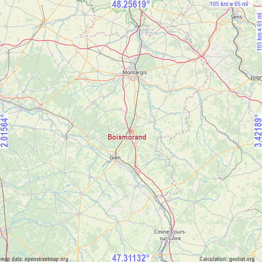
Boismorand GPS coordinates[2]
47° 47' 9.24" North, 2° 43' 7.536" East
| Map corner | latitude | longitude |
|---|---|---|
| Upper-left | 48.25619°, | 2.01564° |
| Center: | 47.7859°, | 2.71876° |
| Lower-right: | 47.31132°, | 3.42189° |
| Map W x H: | 105.1×105.1 km | = 65.3×65.3mi |
| max Lat: | 51.07786° ⇑44.5% North |
| Boismorand: | 47.7859° |
| min Lat: | ⇓55.5% South 41.3874° |
| min Long | Boismorand | max Long |
| -5.08615° | 2.71876° | 9.52242° |
| W 53.8%⇐ | ⇒46.2% E |
Elevation
Elevation of Boismorand is 154 m = 505 ft, and this is 39.7 m = 130 ft below average elevation for this country.
| Max E: |
2333 m = 7654 ft | 43.9% |
| Avg. | 193.7 m = 635 ft | |
| Boismorand | 154 m = 505 ft | |
Min E: |
-1 m = -3 ft | 56.1% |
See also: France elevation on elevation.city.
Geographical zone
Boismorand is located in North temperate zone (between Tropic of Cancer and the Arctic Circle). Distance of this North polar circle is 2087.9 km =1297.4 mi to North.| Distance of | km | miles | from Boismorand |
|---|---|---|---|
| North Pole | 4693.8 | 2916.6 | to North |
| Arctic Circle | 2087.9 | 1297.4 | to North |
| Tropic Cancer | 2707.4 | 1682.3 | to South |
| Equator | 5313.3 | 3301.5 | to South |


Nearby cities:
15 places around Boismorand: (largest is in red/bold)
• Changy-les-Bois
8.4 km =5.2 mi,  342°
342°
• Châtillon-Coligny
10.3 km =6.4 mi,  66°
66°
• Dammarie-sur-Loing
12.1 km =7.5 mi,  91°
91°
• Gien
12.2 km =7.6 mi,  212°
212°
• La Bussière
5.1 km =3.2 mi,  151°
151°
• Montbouy
11.2 km =7 mi,  42°
42°
• Montcresson
14.9 km =9.3 mi,  26°
26°
• Montereau
13.4 km =8.3 mi,  305°
305°
• Nevoy
13.1 km =8.1 mi,  233°
233°
• Nogent-sur-Vernisson
6.9 km =4.3 mi,  14°
14°
• Ouzouer-sur-Trézée
14.3 km =8.9 mi, 152°
• Poilly-lez-Gien
15.1 km =9.4 mi,  216°
216°
• Rogny-les-Sept-Écluses
12.9 km =8 mi,  107°
107°
• Saint-Martin-sur-Ocre
14.8 km =9.2 mi,  197°
197°
• Sainte-Geneviève-des-Bois
8.1 km =5 mi,  64°
64°
Sources, notices
• [Note1] Compared only with cities in France existing in our database
• [Src1] Map data: © OpenStreetMap contributors (CC-BY-SA)
• [Src2] Other city data from geonames.org with taken over terms of usage.
• [Src3] Geographical zone / Annual Mean Temperature by Robert A. Rohde @ Wikipedia
