Jaunay-Clan geodata
Jaunay-Clan (Nouvelle-Aquitaine) is a populated place; located in France in Europe/Paris (GMT+2) time zone. With population of 6,097 people, there are 1621 cities with bigger population in this country. Compared to other cities in France, 58.4% of cities are located further ↑North; 74.6% of cities are located further →East and 72.6% of cities have higher elevation than Jaunay-Clan. Note1
Administrative division(s):
- Level 1: Nouvelle-Aquitaine
- Level 2: Vienne
- Level 3: Arrondissement de Poitiers
- Level 4: Jaunay-Marigny


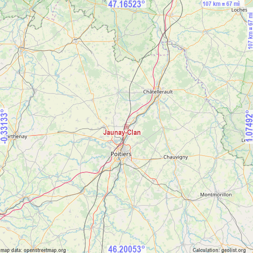
Jaunay-Clan GPS coordinates[2]
46° 41' 6.108" North, 0° 22' 18.444" East
| Map corner | latitude | longitude |
|---|---|---|
| Upper-left | 47.16523°, | -0.33133° |
| Center: | 46.68503°, | 0.37179° |
| Lower-right: | 46.20053°, | 1.07492° |
| Map W x H: | 107.3×107.3 km | = 66.7×66.7mi |
| max Lat: | 51.07786° ⇑58.4% North |
| Jaunay-Clan: | 46.68503° |
| min Lat: | ⇓41.6% South 41.3874° |
| min Long | Jaunay-Clan | max Long |
| -5.08615° | 0.37179° | 9.52242° |
| W 25.4%⇐ | ⇒74.6% E |
Elevation
Elevation of Jaunay-Clan is 72 m = 236 ft, and this is 121.7 m = 399 ft below average elevation for this country.
| Max E: |
2333 m = 7654 ft | 72.6% |
| Avg. | 193.7 m = 635 ft | |
| Jaunay-Clan | 72 m = 236 ft | |
Min E: |
-1 m = -3 ft | 27.4% |
See also: France elevation on elevation.city.
Geographical zone
Jaunay-Clan is located in North temperate zone (between Tropic of Cancer and the Arctic Circle). Distance of this North polar circle is 2210.3 km =1373.4 mi to North.| Distance of | km | miles | from Jaunay-Clan |
|---|---|---|---|
| North Pole | 4816.2 | 2992.6 | to North |
| Arctic Circle | 2210.3 | 1373.4 | to North |
| Tropic Cancer | 2585 | 1606.2 | to South |
| Equator | 5190.9 | 3225.5 | to South |


Nearby cities:
15 places around Jaunay-Clan: (largest is in red/bold)
• Avanton
5.8 km =3.6 mi,  244°
244°
• Beaumont
7.3 km =4.5 mi,  37°
37°
• Buxerolles
11.4 km =7.1 mi,  131°
131°
• Chabournay
9.4 km =5.8 mi,  292°
292°
• Chasseneuil-du-Poitou
3.7 km =2.3 mi,  179°
179°
• Colombiers
10.5 km =6.5 mi,  22°
22°
• Dissay
4.9 km =3 mi,  69°
69°
• Marigny-Brizay
6.9 km =4.3 mi,  3°
3°
• Migné
7.7 km =4.8 mi,  214°
214°
• Montamisé
8.1 km =5 mi,  150°
150°
• Neuville-de-Poitou
9.7 km =6 mi,  270°
270°
• Poitiers
11.6 km =7.2 mi,  190°
190°
• Saint-Cyr
6.5 km =4 mi,  55°
55°
• Saint-Georges-lès-Baillargeaux
2.6 km =1.6 mi, 127°
• Vendeuvre-du-Poitou
7.4 km =4.6 mi,  319°
319°
Sources, notices
• [Note1] Compared only with cities in France existing in our database
• [Src1] Map data: © OpenStreetMap contributors (CC-BY-SA)
• [Src2] Other city data from geonames.org with taken over terms of usage.
• [Src3] Geographical zone / Annual Mean Temperature by Robert A. Rohde @ Wikipedia
