Saint-Georges-lès-Baillargeaux geodata
Saint-Georges-lès-Baillargeaux (Nouvelle-Aquitaine) is a populated place; located in France in Europe/Paris (GMT+2) time zone. With population of 3,363 people, there are 2896 cities with bigger population in this country. Compared to other cities in France, 58.5% of cities are located further ↑North; 74.4% of cities are located further →East and 64% of cities have higher elevation than Saint-Georges-lès-Baillargeaux. Note1
Administrative division(s):
- Level 1: Nouvelle-Aquitaine
- Level 2: Vienne
- Level 3: Arrondissement de Poitiers
- Level 4: Saint-Georges-lès-Baillargeaux
Current local time in Saint-Georges-lès-Baillargeaux:
08:38 AM, SaturdayDifference from your time zone: hours


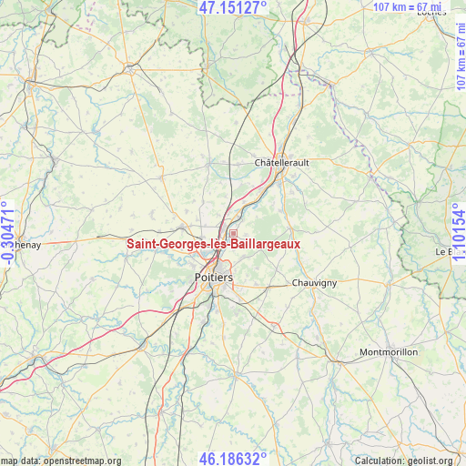
Saint-Georges-lès-Baillargeaux GPS coordinates[2]
46° 40' 15.42" North, 0° 23' 54.312" East
| Map corner | latitude | longitude |
|---|---|---|
| Upper-left | 47.15127°, | -0.30471° |
| Center: | 46.67095°, | 0.39842° |
| Lower-right: | 46.18632°, | 1.10154° |
| Map W x H: | 107.3×107.3 km | = 66.7×66.7mi |
| max Lat: | 51.07786° ⇑58.5% North |
| Saint-Georges-lès-Baillargeaux: | 46.67095° |
| min Lat: | ⇓41.5% South 41.3874° |
| min Long | Saint-Georges-l | max Long |
| -5.08615° | 0.39842° | 9.52242° |
| W 25.6%⇐ | ⇒74.4% E |
Elevation
Elevation of Saint-Georges-lès-Baillargeaux is 92 m = 302 ft, and this is 101.7 m = 334 ft below average elevation for this country.
| Max E: |
2333 m = 7654 ft | 64% |
| Avg. | 193.7 m = 635 ft | |
| Saint-Georges-lès-Baillargeaux | 92 m = 302 ft | |
Min E: |
-1 m = -3 ft | 36% |
See also: France elevation on elevation.city.
Geographical zone
Saint-Georges-lès-Baillargeaux is located in North temperate zone (between Tropic of Cancer and the Arctic Circle). Distance of this North polar circle is 2211.9 km =1374.4 mi to North.| Distance of | km | miles | from Saint-Georges-lès-Baillargeaux |
|---|---|---|---|
| North Pole | 4817.7 | 2993.6 | to North |
| Arctic Circle | 2211.9 | 1374.4 | to North |
| Tropic Cancer | 2583.4 | 1605.2 | to South |
| Equator | 5189.3 | 3224.5 | to South |


Nearby cities:
15 places around Saint-Georges-lès-Baillargeaux: (largest is in red/bold)
• Avanton
7.3 km =4.5 mi,  263°
263°
• Beaumont
7.7 km =4.8 mi,  17°
17°
• Bignoux
9.6 km =6 mi,  145°
145°
• Buxerolles
8.9 km =5.5 mi,  132°
132°
• Chasseneuil-du-Poitou
3 km =1.9 mi,  222°
222°
• Colombiers
11.4 km =7.1 mi,  10°
10°
• Dissay
4.2 km =2.6 mi,  37°
37°
• Jaunay-Clan
2.6 km =1.6 mi,  307°
307°
• Marigny-Brizay
8.6 km =5.3 mi,  348°
348°
• Migné
8 km =5 mi,  232°
232°
• Montamisé
5.9 km =3.7 mi,  159°
159°
• Poitiers
10.7 km =6.6 mi,  203°
203°
• Roman catholic diocese of Poitiers
10.8 km =6.7 mi, 200°
• Saint-Cyr
6.3 km =3.9 mi,  32°
32°
• Vendeuvre-du-Poitou
9.9 km =6.2 mi,  316°
316°
Sources, notices
• [Note1] Compared only with cities in France existing in our database
• [Src1] Map data: © OpenStreetMap contributors (CC-BY-SA)
• [Src2] Other city data from geonames.org with taken over terms of usage.
• [Src3] Geographical zone / Annual Mean Temperature by Robert A. Rohde @ Wikipedia
