Saint-Cyr geodata
Saint-Cyr (Nouvelle-Aquitaine) is a populated place; located in France in Europe/Paris (GMT+2) time zone. With population of 836 people, there are 10228 cities with bigger population in this country. Compared to other cities in France, 58.1% of cities are located further ↑North; 73.9% of cities are located further →East and 77.8% of cities have higher elevation than Saint-Cyr. Note1
Administrative division(s):
- Level 1: Nouvelle-Aquitaine
- Level 2: Vienne
- Level 3: Arrondissement de Poitiers
- Level 4: Beaumont Saint-Cyr


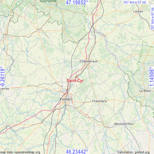
Saint-Cyr GPS coordinates[2]
46° 43' 7.032" North, 0° 26' 30.984" East
| Map corner | latitude | longitude |
|---|---|---|
| Upper-left | 47.19852°, | -0.26119° |
| Center: | 46.71862°, | 0.44194° |
| Lower-right: | 46.23442°, | 1.14506° |
| Map W x H: | 107.2×107.2 km | = 66.6×66.6mi |
| max Lat: | 51.07786° ⇑58.1% North |
| Saint-Cyr: | 46.71862° |
| min Lat: | ⇓41.9% South 41.3874° |
| min Long | Saint-Cyr | max Long |
| -5.08615° | 0.44194° | 9.52242° |
| W 26.1%⇐ | ⇒73.9% E |
Elevation
Elevation of Saint-Cyr is 60 m = 197 ft, and this is 133.7 m = 439 ft below average elevation for this country.
| Max E: |
2333 m = 7654 ft | 77.8% |
| Avg. | 193.7 m = 635 ft | |
| Saint-Cyr | 60 m = 197 ft | |
Min E: |
-1 m = -3 ft | 22.2% |
See also: France elevation on elevation.city.
Geographical zone
Saint-Cyr is located in North temperate zone (between Tropic of Cancer and the Arctic Circle). Distance of this North polar circle is 2206.6 km =1371.1 mi to North.| Distance of | km | miles | from Saint-Cyr |
|---|---|---|---|
| North Pole | 4812.4 | 2990.3 | to North |
| Arctic Circle | 2206.6 | 1371.1 | to North |
| Tropic Cancer | 2588.7 | 1608.5 | to South |
| Equator | 5194.6 | 3227.8 | to South |


Nearby cities:
15 places around Saint-Cyr: (largest is in red/bold)
• Beaumont
2.2 km =1.4 mi,  335°
335°
• Bonneuil-Matours
10.6 km =6.6 mi,  112°
112°
• Buxerolles
11.8 km =7.3 mi,  164°
164°
• Cenon-sur-Vienne
9.5 km =5.9 mi,  49°
49°
• Chasseneuil-du-Poitou
9.2 km =5.7 mi,  215°
215°
• Colombiers
6.1 km =3.8 mi,  347°
347°
• Dissay
2.1 km =1.3 mi,  201°
201°
• Jaunay-Clan
6.5 km =4 mi,  235°
235°
• Marigny-Brizay
5.9 km =3.7 mi,  301°
301°
• Montamisé
10.9 km =6.8 mi,  186°
186°
• Naintré
5.8 km =3.6 mi,  32°
32°
• Saint-Georges-lès-Baillargeaux
6.3 km =3.9 mi,  212°
212°
• Scorbé-Clairvaux
10.7 km =6.6 mi, 348°
• Vendeuvre-du-Poitou
10.3 km =6.4 mi,  280°
280°
• Vouneuil-sur-Vienne
7.5 km =4.7 mi,  90°
90°
Sources, notices
• [Note1] Compared only with cities in France existing in our database
• [Src1] Map data: © OpenStreetMap contributors (CC-BY-SA)
• [Src2] Other city data from geonames.org with taken over terms of usage.
• [Src3] Geographical zone / Annual Mean Temperature by Robert A. Rohde @ Wikipedia
