Janzé geodata
Janzé (Brittany) is a populated place; located in France in Europe/Paris (GMT+2) time zone. With population of 5,927 people, there are 1665 cities with bigger population in this country. Compared to other cities in France, 58.6% of cities are located further ↓South; 92.2% of cities are located further →East and 66.6% of cities have higher elevation than Janzé. Note1
Administrative division(s):
- Level 1: Brittany
- Level 2: Département d'Ille-et-Vilaine
- Level 3: Arrondissement de Fougères-Vitré
- Level 4: Janzé


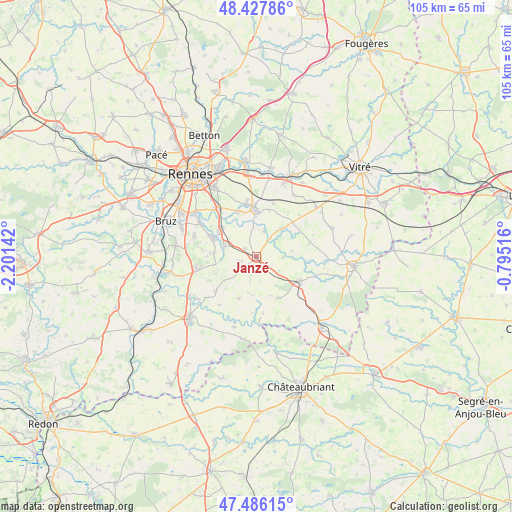
Janzé GPS coordinates[2]
47° 57' 32.94" North, 1° 29' 53.844" West
| Map corner | latitude | longitude |
|---|---|---|
| Upper-left | 48.42786°, | -2.20142° |
| Center: | 47.95915°, | -1.49829° |
| Lower-right: | 47.48615°, | -0.79516° |
| Map W x H: | 104.7×104.7 km | = 65.1×65.1mi |
| max Lat: | 51.07786° ⇑41.4% North |
| Janzé: | 47.95915° |
| min Lat: | ⇓58.6% South 41.3874° |
| min Long | Janzé | max Long |
| -5.08615° | -1.49829° | 9.52242° |
| W 7.8%⇐ | ⇒92.2% E |
Elevation
Elevation of Janzé is 86 m = 282 ft, and this is 107.7 m = 353 ft below average elevation for this country.
| Max E: |
2333 m = 7654 ft | 66.6% |
| Avg. | 193.7 m = 635 ft | |
| Janzé | 86 m = 282 ft | |
Min E: |
-1 m = -3 ft | 33.4% |
See also: France elevation on elevation.city.
Geographical zone
Janzé is located in North temperate zone (between Tropic of Cancer and the Arctic Circle). Distance of this North polar circle is 2068.6 km =1285.4 mi to North.| Distance of | km | miles | from Janzé |
|---|---|---|---|
| North Pole | 4674.5 | 2904.6 | to North |
| Arctic Circle | 2068.6 | 1285.4 | to North |
| Tropic Cancer | 2726.6 | 1694.2 | to South |
| Equator | 5332.6 | 3313.5 | to South |


Nearby cities:
15 places around Janzé: (largest is in red/bold)
• Amanlis
5.6 km =3.5 mi,  16°
16°
• Boistrudan
7.3 km =4.5 mi,  80°
80°
• Bourgbarré
9.5 km =5.9 mi,  294°
294°
• Brie
3 km =1.9 mi,  253°
253°
• Chanteloup
8.7 km =5.4 mi,  274°
274°
• Châteaugiron
9.7 km =6 mi,  357°
357°
• Corps-Nuds
6.8 km =4.2 mi, 289°
• Coësmes
9.5 km =5.9 mi,  153°
153°
• Essé
5.5 km =3.4 mi,  92°
92°
• Le Petit-Fougeray
8.9 km =5.5 mi, 246°
• Le Theil-de-Bretagne
6.7 km =4.2 mi,  130°
130°
• Piré-sur-Seiche
7.6 km =4.7 mi,  42°
42°
• Saint-Armel
9.2 km =5.7 mi,  310°
310°
• Saulnières
8.1 km =5 mi,  233°
233°
• Tresbœuf
9.3 km =5.8 mi,  204°
204°
Sources, notices
• [Note1] Compared only with cities in France existing in our database
• [Src1] Map data: © OpenStreetMap contributors (CC-BY-SA)
• [Src2] Other city data from geonames.org with taken over terms of usage.
• [Src3] Geographical zone / Annual Mean Temperature by Robert A. Rohde @ Wikipedia
