Le Petit-Fougeray geodata
Le Petit-Fougeray (Brittany) is a populated place; located in France in Europe/Paris (GMT+2) time zone. With population of 602 people, there are 13285 cities with bigger population in this country. Compared to other cities in France, 58% of cities are located further ↓South; 93% of cities are located further →East and 59.4% of cities have higher elevation than Le Petit-Fougeray. Note1
Administrative division(s):
- Level 1: Brittany
- Level 2: Département d'Ille-et-Vilaine
- Level 3: Arrondissement de Redon
- Level 4: Le Petit-Fougeray


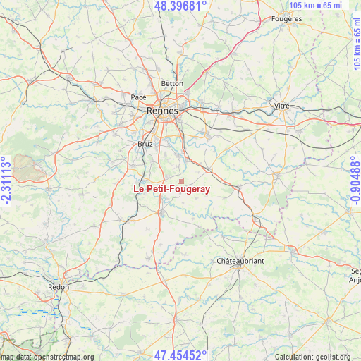
Le Petit-Fougeray GPS coordinates[2]
47° 55' 40.116" North, 1° 36' 28.8" West
| Map corner | latitude | longitude |
|---|---|---|
| Upper-left | 48.39681°, | -2.31113° |
| Center: | 47.92781°, | -1.608° |
| Lower-right: | 47.45452°, | -0.90488° |
| Map W x H: | 104.8×104.8 km | = 65.1×65.1mi |
| max Lat: | 51.07786° ⇑42% North |
| Le Petit-Fougeray: | 47.92781° |
| min Lat: | ⇓58% South 41.3874° |
| min Long | Le Petit-Fouger | max Long |
| -5.08615° | -1.608° | 9.52242° |
| W 7%⇐ | ⇒93% E |
Elevation
Elevation of Le Petit-Fougeray is 104 m = 341 ft, and this is 89.7 m = 294 ft below average elevation for this country.
| Max E: |
2333 m = 7654 ft | 59.4% |
| Avg. | 193.7 m = 635 ft | |
| Le Petit-Fougeray | 104 m = 341 ft | |
Min E: |
-1 m = -3 ft | 40.6% |
See also: France elevation on elevation.city.
Geographical zone
Le Petit-Fougeray is located in North temperate zone (between Tropic of Cancer and the Arctic Circle). Distance of this North polar circle is 2072.1 km =1287.5 mi to North.| Distance of | km | miles | from Le Petit-Fougeray |
|---|---|---|---|
| North Pole | 4678 | 2906.8 | to North |
| Arctic Circle | 2072.1 | 1287.5 | to North |
| Tropic Cancer | 2723.2 | 1692.1 | to South |
| Equator | 5329.1 | 3311.3 | to South |


Nearby cities:
15 places around Le Petit-Fougeray: (largest is in red/bold)
• Bourg-des-Comptes
10.2 km =6.3 mi,  270°
270°
• Bourgbarré
7.5 km =4.7 mi,  356°
356°
• Brie
5.9 km =3.7 mi,  63°
63°
• Chanteloup
4.3 km =2.7 mi,  352°
352°
• Corps-Nuds
6 km =3.7 mi,  17°
17°
• Crevin
4.4 km =2.7 mi,  277°
277°
• Janzé
8.9 km =5.5 mi,  66°
66°
• Laillé
9.9 km =6.2 mi,  304°
304°
• Le Sel-de-Bretagne
3.2 km =2 mi,  191°
191°
• Orgères
9.1 km =5.7 mi,  330°
330°
• Pancé
6.4 km =4 mi,  216°
216°
• Poligné
7.3 km =4.5 mi,  232°
232°
• Saint-Armel
9.6 km =6 mi,  7°
7°
• Saulnières
2.2 km =1.4 mi,  129°
129°
• Tresbœuf
6.6 km =4.1 mi,  138°
138°
Sources, notices
• [Note1] Compared only with cities in France existing in our database
• [Src1] Map data: © OpenStreetMap contributors (CC-BY-SA)
• [Src2] Other city data from geonames.org with taken over terms of usage.
• [Src3] Geographical zone / Annual Mean Temperature by Robert A. Rohde @ Wikipedia
