Le Grand-Lemps geodata
Le Grand-Lemps (Auvergne-Rhône-Alpes) is a populated place; located in France in Europe/Paris (GMT+2) time zone. With population of 2,566 people, there are 3796 cities with bigger population in this country. Compared to other cities in France, 75.3% of cities are located further ↑North; 82.2% of cities are located further ←West and 91.8% of cities have lower elevation than Le Grand-Lemps. Note1
Administrative division(s):
- Level 1: Auvergne-Rhône-Alpes
- Level 2: Département de l'Isère
- Level 3: Arrondissement de La Tour-du-Pin
- Level 4: Le Grand-Lemps


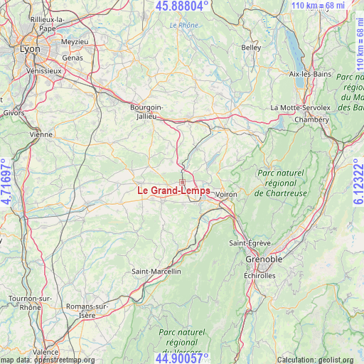
Le Grand-Lemps GPS coordinates[2]
45° 23' 47.256" North, 5° 25' 12.36" East
| Map corner | latitude | longitude |
|---|---|---|
| Upper-left | 45.88804°, | 4.71697° |
| Center: | 45.39646°, | 5.4201° |
| Lower-right: | 44.90057°, | 6.12322° |
| Map W x H: | 109.8×109.8 km | = 68.2×68.2mi |
| max Lat: | 51.07786° ⇑75.3% North |
| Le Grand-Lemps: | 45.39646° |
| min Lat: | ⇓24.7% South 41.3874° |
| min Long | Le Grand-Lemps | max Long |
| -5.08615° | 5.4201° | 9.52242° |
| W 82.2%⇐ | ⇒17.8% E |
Elevation
Elevation of Le Grand-Lemps is 468 m = 1535 ft, and this is 274.3 m = 900 ft above average elevation for this country.
| Max E: |
2333 m = 7654 ft | 8.2% |
| Le Grand-Lemps | 468 m 1535 ft | |
| Avg. | 193.7 m = 635 ft | |
Min E: |
-1 m = -3 ft | 91.8% |
See also: France elevation on elevation.city.
Geographical zone
Le Grand-Lemps is located in North temperate zone (between Tropic of Cancer and the Arctic Circle). Distance of this North polar circle is 2353.6 km =1462.5 mi to North.| Distance of | km | miles | from Le Grand-Lemps |
|---|---|---|---|
| North Pole | 4959.4 | 3081.6 | to North |
| Arctic Circle | 2353.6 | 1462.5 | to North |
| Tropic Cancer | 2441.7 | 1517.2 | to South |
| Equator | 5047.6 | 3136.4 | to South |


Nearby cities:
15 places around Le Grand-Lemps: (largest is in red/bold)
• Apprieu
6.2 km =3.9 mi,  90°
90°
• Beaucroissant
7.2 km =4.5 mi,  146°
146°
• Bizonnes
7 km =4.3 mi,  333°
333°
• Bévenais
2 km =1.2 mi,  270°
270°
• Charavines
8.2 km =5.1 mi,  64°
64°
• Châbons
5.2 km =3.2 mi,  4°
4°
• Colombe
2.7 km =1.7 mi,  81°
81°
• Izeaux
6.9 km =4.3 mi,  176°
176°
• La Frette
4.8 km =3 mi,  260°
260°
• Oyeu
5.1 km =3.2 mi, 56°
• Rives
7.9 km =4.9 mi,  127°
127°
• Saint-Blaise-du-Buis
7.9 km =4.9 mi,  105°
105°
• Saint-Hilaire-de-la-Côte
8.2 km =5.1 mi, 266°
• Saint-Étienne-de-Saint-Geoirs
8.6 km =5.3 mi,  222°
222°
• Sillans
6.5 km =4 mi,  202°
202°
Sources, notices
• [Note1] Compared only with cities in France existing in our database
• [Src1] Map data: © OpenStreetMap contributors (CC-BY-SA)
• [Src2] Other city data from geonames.org with taken over terms of usage.
• [Src3] Geographical zone / Annual Mean Temperature by Robert A. Rohde @ Wikipedia
