Houx geodata
Houx (Centre) is a populated place; located in France in Europe/Paris (GMT+2) time zone. With population of 671 people, there are 12198 cities with bigger population in this country. Compared to other cities in France, 70% of cities are located further ↓South; 61.4% of cities are located further →East and 56.9% of cities have higher elevation than Houx. Note1
Administrative division(s):
- Level 1: Centre
- Level 2: Département d'Eure-et-Loir
- Level 3: Arrondissement de Chartres
- Level 4: Houx


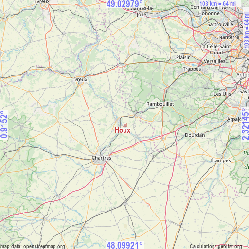
Houx GPS coordinates[2]
48° 33' 59.904" North, 1° 37' 5.988" East
| Map corner | latitude | longitude |
|---|---|---|
| Upper-left | 49.02979°, | 0.9152° |
| Center: | 48.56664°, | 1.61833° |
| Lower-right: | 48.09921°, | 2.32145° |
| Map W x H: | 103.5×103.5 km | = 64.3×64.3mi |
| max Lat: | 51.07786° ⇑30% North |
| Houx: | 48.56664° |
| min Lat: | ⇓70% South 41.3874° |
| min Long | Houx | max Long |
| -5.08615° | 1.61833° | 9.52242° |
| W 38.6%⇐ | ⇒61.4% E |
Elevation
Elevation of Houx is 111 m = 364 ft, and this is 82.7 m = 271 ft below average elevation for this country.
| Max E: |
2333 m = 7654 ft | 56.9% |
| Avg. | 193.7 m = 635 ft | |
| Houx | 111 m = 364 ft | |
Min E: |
-1 m = -3 ft | 43.1% |
See also: France elevation on elevation.city.
Geographical zone
Houx is located in North temperate zone (between Tropic of Cancer and the Arctic Circle). Distance of this North polar circle is 2001.1 km =1243.4 mi to North.| Distance of | km | miles | from Houx |
|---|---|---|---|
| North Pole | 4607 | 2862.7 | to North |
| Arctic Circle | 2001.1 | 1243.4 | to North |
| Tropic Cancer | 2794.2 | 1736.2 | to South |
| Equator | 5400.1 | 3355.5 | to South |


Nearby cities:
15 places around Houx: (largest is in red/bold)
• Armenonville-les-Gâtineaux
3.3 km =2.1 mi,  139°
139°
• Bouglainval
7.9 km =4.9 mi,  267°
267°
• Chartainvilliers
5.3 km =3.3 mi,  242°
242°
• Droue-sur-Drouette
7.2 km =4.5 mi,  58°
58°
• Gallardon
7.1 km =4.4 mi,  129°
129°
• Gas
3.6 km =2.2 mi,  89°
89°
• Hanches
4.5 km =2.8 mi,  32°
32°
• Maintenon
3.7 km =2.3 mi,  307°
307°
• Mévoisins
2.5 km =1.6 mi,  227°
227°
• Pierres
4.9 km =3 mi, 305°
• Saint-Martin-de-Nigelles
5.1 km =3.2 mi,  352°
352°
• Saint-Piat
3.4 km =2.1 mi, 229°
• Villiers-le-Morhier
7.2 km =4.5 mi,  325°
325°
• Yermenonville
1.1 km =0.7 mi,  173°
173°
• Épernon
6.3 km =3.9 mi,  39°
39°
Sources, notices
• [Note1] Compared only with cities in France existing in our database
• [Src1] Map data: © OpenStreetMap contributors (CC-BY-SA)
• [Src2] Other city data from geonames.org with taken over terms of usage.
• [Src3] Geographical zone / Annual Mean Temperature by Robert A. Rohde @ Wikipedia
