Épernon geodata
Épernon (Centre) is a populated place; located in France in Europe/Paris (GMT+2) time zone. With population of 5,266 people, there are 1869 cities with bigger population in this country. Compared to other cities in France, 71.1% of cities are located further ↓South; 60.7% of cities are located further →East and 54.4% of cities have higher elevation than Épernon. Note1
Administrative division(s):
- Level 1: Centre
- Level 2: Département d'Eure-et-Loir
- Level 3: Arrondissement de Chartres
- Level 4: Épernon


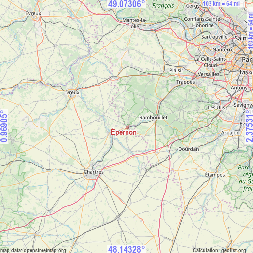
Épernon GPS coordinates[2]
48° 36' 37.116" North, 1° 40' 19.848" East
| Map corner | latitude | longitude |
|---|---|---|
| Upper-left | 49.07306°, | 0.96905° |
| Center: | 48.61031°, | 1.67218° |
| Lower-right: | 48.14328°, | 2.37531° |
| Map W x H: | 103.4×103.4 km | = 64.2×64.2mi |
| max Lat: | 51.07786° ⇑28.9% North |
| Épernon: | 48.61031° |
| min Lat: | ⇓71.1% South 41.3874° |
| min Long | Épernon | max Long |
| -5.08615° | 1.67218° | 9.52242° |
| W 39.3%⇐ | ⇒60.7% E |
Elevation
Elevation of Épernon is 118 m = 387 ft, and this is 75.7 m = 248 ft below average elevation for this country.
| Max E: |
2333 m = 7654 ft | 54.4% |
| Avg. | 193.7 m = 635 ft | |
| Épernon | 118 m = 387 ft | |
Min E: |
-1 m = -3 ft | 45.6% |
See also: France elevation on elevation.city.
Geographical zone
Épernon is located in North temperate zone (between Tropic of Cancer and the Arctic Circle). Distance of this North polar circle is 1996.2 km =1240.4 mi to North.| Distance of | km | miles | from Épernon |
|---|---|---|---|
| North Pole | 4602.1 | 2859.6 | to North |
| Arctic Circle | 1996.2 | 1240.4 | to North |
| Tropic Cancer | 2799 | 1739.2 | to South |
| Equator | 5405 | 3358.5 | to South |


Nearby cities:
15 places around Épernon: (largest is in red/bold)
• Armenonville-les-Gâtineaux
7.6 km =4.7 mi,  193°
193°
• Droue-sur-Drouette
2.4 km =1.5 mi,  117°
117°
• Gas
4.9 km =3 mi,  184°
184°
• Gazeran
7.7 km =4.8 mi,  71°
71°
• Hanches
1.8 km =1.1 mi,  236°
236°
• Houx
6.3 km =3.9 mi,  219°
219°
• La Boissière-École
7.9 km =4.9 mi,  348°
348°
• Maintenon
7.4 km =4.6 mi,  249°
249°
• Mittainville
7 km =4.3 mi,  344°
344°
• Raizeux
1.8 km =1.1 mi,  27°
27°
• Saint-Hilarion
4.7 km =2.9 mi,  75°
75°
• Saint-Martin-de-Nigelles
4.6 km =2.9 mi,  272°
272°
• Villiers-le-Morhier
8.1 km =5 mi,  277°
277°
• Yermenonville
7 km =4.3 mi,  212°
212°
• Émancé
4.9 km =3 mi, 116°
Sources, notices
• [Note1] Compared only with cities in France existing in our database
• [Src1] Map data: © OpenStreetMap contributors (CC-BY-SA)
• [Src2] Other city data from geonames.org with taken over terms of usage.
• [Src3] Geographical zone / Annual Mean Temperature by Robert A. Rohde @ Wikipedia
