Droue-sur-Drouette geodata
Droue-sur-Drouette (Centre) is a populated place; located in France in Europe/Paris (GMT+2) time zone. With population of 1,158 people, there are 7774 cities with bigger population in this country. Compared to other cities in France, 70.9% of cities are located further ↓South; 60.4% of cities are located further →East and 51.4% of cities have higher elevation than Droue-sur-Drouette. Note1
Administrative division(s):
- Level 1: Centre
- Level 2: Département d'Eure-et-Loir
- Level 3: Arrondissement de Chartres
- Level 4: Droue-sur-Drouette


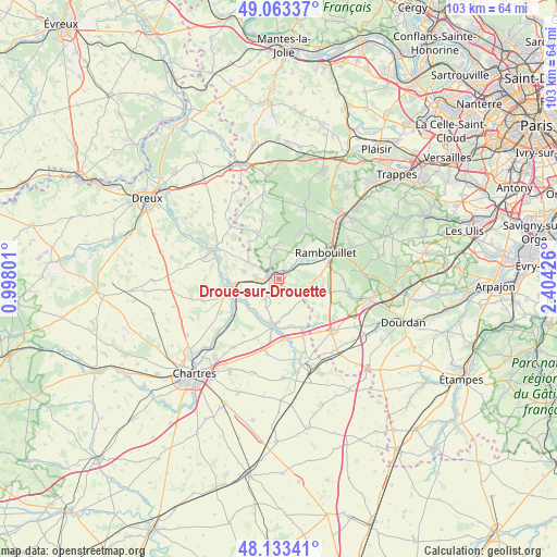
Droue-sur-Drouette GPS coordinates[2]
48° 36' 1.908" North, 1° 42' 4.068" East
| Map corner | latitude | longitude |
|---|---|---|
| Upper-left | 49.06337°, | 0.99801° |
| Center: | 48.60053°, | 1.70113° |
| Lower-right: | 48.13341°, | 2.40426° |
| Map W x H: | 103.4×103.4 km | = 64.2×64.2mi |
| max Lat: | 51.07786° ⇑29.1% North |
| Droue-sur-Drouette: | 48.60053° |
| min Lat: | ⇓70.9% South 41.3874° |
| min Long | Droue-sur-Droue | max Long |
| -5.08615° | 1.70113° | 9.52242° |
| W 39.6%⇐ | ⇒60.4% E |
Elevation
Elevation of Droue-sur-Drouette is 127 m = 417 ft, and this is 66.7 m = 219 ft below average elevation for this country.
| Max E: |
2333 m = 7654 ft | 51.4% |
| Avg. | 193.7 m = 635 ft | |
| Droue-sur-Drouette | 127 m = 417 ft | |
Min E: |
-1 m = -3 ft | 48.6% |
See also: France elevation on elevation.city.
Geographical zone
Droue-sur-Drouette is located in North temperate zone (between Tropic of Cancer and the Arctic Circle). Distance of this North polar circle is 1997.3 km =1241.1 mi to North.| Distance of | km | miles | from Droue-sur-Drouette |
|---|---|---|---|
| North Pole | 4603.2 | 2860.3 | to North |
| Arctic Circle | 1997.3 | 1241.1 | to North |
| Tropic Cancer | 2798 | 1738.6 | to South |
| Equator | 5403.9 | 3357.8 | to South |


Nearby cities:
15 places around Droue-sur-Drouette: (largest is in red/bold)
• Armenonville-les-Gâtineaux
7.5 km =4.7 mi,  211°
211°
• Gallardon
8.3 km =5.2 mi,  184°
184°
• Gas
4.5 km =2.8 mi, 213°
• Gazeran
6.3 km =3.9 mi,  55°
55°
• Hanches
3.7 km =2.3 mi,  271°
271°
• Houx
7.2 km =4.5 mi,  238°
238°
• Orcemont
8.2 km =5.1 mi,  99°
99°
• Orphin
6.3 km =3.9 mi,  112°
112°
• Raizeux
3 km =1.9 mi,  333°
333°
• Saint-Hilarion
3.3 km =2.1 mi,  47°
47°
• Saint-Martin-de-Nigelles
6.9 km =4.3 mi,  280°
280°
• Yermenonville
7.7 km =4.8 mi,  231°
231°
• Écrosnes
6.4 km =4 mi,  161°
161°
• Émancé
2.5 km =1.6 mi,  116°
116°
• Épernon
2.4 km =1.5 mi,  297°
297°
Sources, notices
• [Note1] Compared only with cities in France existing in our database
• [Src1] Map data: © OpenStreetMap contributors (CC-BY-SA)
• [Src2] Other city data from geonames.org with taken over terms of usage.
• [Src3] Geographical zone / Annual Mean Temperature by Robert A. Rohde @ Wikipedia
