Hondouville geodata
Hondouville (Normandy) is a populated place; located in France in Europe/Paris (GMT+2) time zone. With population of 758 people, there are 11078 cities with bigger population in this country. Compared to other cities in France, 83.1% of cities are located further ↓South; 67.7% of cities are located further →East and 89.9% of cities have higher elevation than Hondouville. Note1
Administrative division(s):
- Level 1: Normandy
- Level 2: Département de l'Eure
- Level 3: Arrondissement de Bernay
- Level 4: Hondouville


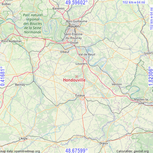
Hondouville GPS coordinates[2]
49° 8' 17.304" North, 1° 7' 11.748" East
| Map corner | latitude | longitude |
|---|---|---|
| Upper-left | 49.59602°, | 0.41681° |
| Center: | 49.13814°, | 1.11993° |
| Lower-right: | 48.67599°, | 1.82306° |
| Map W x H: | 102.3×102.3 km | = 63.6×63.6mi |
| max Lat: | 51.07786° ⇑16.9% North |
| Hondouville: | 49.13814° |
| min Lat: | ⇓83.1% South 41.3874° |
| min Long | Hondouville | max Long |
| -5.08615° | 1.11993° | 9.52242° |
| W 32.3%⇐ | ⇒67.7% E |
Elevation
Elevation of Hondouville is 30 m = 98 ft, and this is 163.7 m = 537 ft below average elevation for this country.
| Max E: |
2333 m = 7654 ft | 89.9% |
| Avg. | 193.7 m = 635 ft | |
| Hondouville | 30 m = 98 ft | |
Min E: |
-1 m = -3 ft | 10.1% |
See also: France elevation on elevation.city.
Geographical zone
Hondouville is located in North temperate zone (between Tropic of Cancer and the Arctic Circle). Distance of this North polar circle is 1937.5 km =1203.9 mi to North.| Distance of | km | miles | from Hondouville |
|---|---|---|---|
| North Pole | 4543.4 | 2823.1 | to North |
| Arctic Circle | 1937.5 | 1203.9 | to North |
| Tropic Cancer | 2857.7 | 1775.7 | to South |
| Equator | 5463.6 | 3394.9 | to South |


Nearby cities:
15 places around Hondouville: (largest is in red/bold)
• Acquigny
5.7 km =3.5 mi,  46°
46°
• Amfreville-sur-Iton
2.5 km =1.6 mi,  67°
67°
• Brosville
4.2 km =2.6 mi,  183°
183°
• Canappeville
2.5 km =1.6 mi,  323°
323°
• Fontaine-Heudebourg
6.9 km =4.3 mi,  97°
97°
• Heudreville-sur-Eure
5 km =3.1 mi,  86°
86°
• La Vacherie
1.1 km =0.7 mi,  141°
141°
• Le Boulay-Morin
7.6 km =4.7 mi, 142°
• Louviers
9.4 km =5.8 mi,  21°
21°
• Normanville
7.2 km =4.5 mi,  156°
156°
• Pinterville
7.2 km =4.5 mi,  34°
34°
• Quittebeuf
8.2 km =5.1 mi,  247°
247°
• Sacquenville
6.9 km =4.3 mi,  209°
209°
• Surville
6.8 km =4.2 mi,  349°
349°
• Émalleville
5.4 km =3.4 mi,  146°
146°
Sources, notices
• [Note1] Compared only with cities in France existing in our database
• [Src1] Map data: © OpenStreetMap contributors (CC-BY-SA)
• [Src2] Other city data from geonames.org with taken over terms of usage.
• [Src3] Geographical zone / Annual Mean Temperature by Robert A. Rohde @ Wikipedia
