Surville geodata
Surville (Normandy) is a populated place; located in France in Europe/Paris (GMT+2) time zone. With population of 773 people, there are 10903 cities with bigger population in this country. Compared to other cities in France, 84.2% of cities are located further ↓South; 67.8% of cities are located further →East and 54.2% of cities have lower elevation than Surville. Note1
Administrative division(s):
- Level 1: Normandy
- Level 2: Département de l'Eure
- Level 3: Les Andelys
- Level 4: Surville


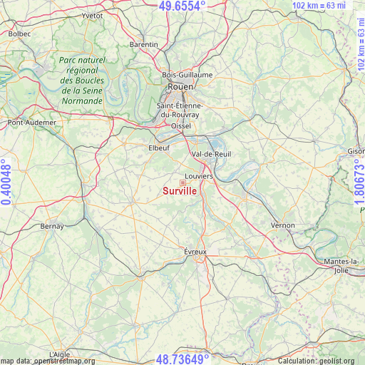
Surville GPS coordinates[2]
49° 11' 53.088" North, 1° 6' 12.96" East
| Map corner | latitude | longitude |
|---|---|---|
| Upper-left | 49.6554°, | 0.40048° |
| Center: | 49.19808°, | 1.1036° |
| Lower-right: | 48.73649°, | 1.80673° |
| Map W x H: | 102.2×102.2 km | = 63.5×63.5mi |
| max Lat: | 51.07786° ⇑15.8% North |
| Surville: | 49.19808° |
| min Lat: | ⇓84.2% South 41.3874° |
| min Long | Surville | max Long |
| -5.08615° | 1.1036° | 9.52242° |
| W 32.2%⇐ | ⇒67.8% E |
Elevation
Elevation of Surville is 147 m = 482 ft, and this is 46.7 m = 153 ft below average elevation for this country.
| Max E: |
2333 m = 7654 ft | 45.8% |
| Avg. | 193.7 m = 635 ft | |
| Surville | 147 m = 482 ft | |
Min E: |
-1 m = -3 ft | 54.2% |
See also: France elevation on elevation.city.
Geographical zone
Surville is located in North temperate zone (between Tropic of Cancer and the Arctic Circle). Distance of this North polar circle is 1930.9 km =1199.8 mi to North.| Distance of | km | miles | from Surville |
|---|---|---|---|
| North Pole | 4536.7 | 2819 | to North |
| Arctic Circle | 1930.9 | 1199.8 | to North |
| Tropic Cancer | 2864.4 | 1779.9 | to South |
| Equator | 5470.3 | 3399.1 | to South |


Nearby cities:
15 places around Surville: (largest is in red/bold)
• Acquigny
6 km =3.7 mi,  117°
117°
• Amfreville-sur-Iton
6.7 km =4.2 mi,  148°
148°
• Canappeville
4.6 km =2.9 mi,  183°
183°
• Heudebouville
9.9 km =6.2 mi,  92°
92°
• Heudreville-sur-Eure
8.8 km =5.5 mi,  135°
135°
• Hondouville
6.8 km =4.2 mi,  169°
169°
• La Haye-Malherbe
4 km =2.5 mi,  319°
319°
• La Vacherie
7.7 km =4.8 mi, 166°
• Le Vaudreuil
9.9 km =6.2 mi,  51°
51°
• Louviers
5 km =3.1 mi,  65°
65°
• Montaure
4.2 km =2.6 mi,  344°
344°
• Pinterville
5.3 km =3.3 mi,  97°
97°
• Saint-Didier-des-Bois
6.9 km =4.3 mi,  310°
310°
• Saint-Pierre-du-Vauvray
9.3 km =5.8 mi, 66°
• Saint-Étienne-du-Vauvray
9.7 km =6 mi,  60°
60°
Sources, notices
• [Note1] Compared only with cities in France existing in our database
• [Src1] Map data: © OpenStreetMap contributors (CC-BY-SA)
• [Src2] Other city data from geonames.org with taken over terms of usage.
• [Src3] Geographical zone / Annual Mean Temperature by Robert A. Rohde @ Wikipedia
