Gétigné geodata
Gétigné (Pays de la Loire) is a populated place; located in France in Europe/Paris (GMT+2) time zone. With population of 3,326 people, there are 2935 cities with bigger population in this country. Compared to other cities in France, 54.5% of cities are located further ↑North; 90.4% of cities are located further →East and 89.9% of cities have higher elevation than Gétigné. Note1
Administrative division(s):
- Level 1: Pays de la Loire
- Level 2: Loire-Atlantique
- Level 3: Arrondissement de Nantes
- Level 4: Gétigné


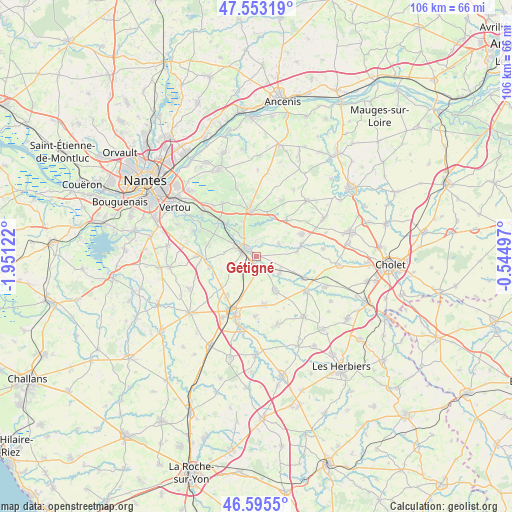
Gétigné GPS coordinates[2]
47° 4' 35.4" North, 1° 14' 53.16" West
| Map corner | latitude | longitude |
|---|---|---|
| Upper-left | 47.55319°, | -1.95122° |
| Center: | 47.0765°, | -1.2481° |
| Lower-right: | 46.5955°, | -0.54497° |
| Map W x H: | 106.5×106.5 km | = 66.2×66.2mi |
| max Lat: | 51.07786° ⇑54.5% North |
| Gétigné: | 47.0765° |
| min Lat: | ⇓45.5% South 41.3874° |
| min Long | Gétigné | max Long |
| -5.08615° | -1.2481° | 9.52242° |
| W 9.6%⇐ | ⇒90.4% E |
Elevation
Elevation of Gétigné is 30 m = 98 ft, and this is 163.7 m = 537 ft below average elevation for this country.
| Max E: |
2333 m = 7654 ft | 89.9% |
| Avg. | 193.7 m = 635 ft | |
| Gétigné | 30 m = 98 ft | |
Min E: |
-1 m = -3 ft | 10.1% |
See also: France elevation on elevation.city.
Geographical zone
Gétigné is located in North temperate zone (between Tropic of Cancer and the Arctic Circle). Distance of this North polar circle is 2166.8 km =1346.4 mi to North.| Distance of | km | miles | from Gétigné |
|---|---|---|---|
| North Pole | 4772.6 | 2965.6 | to North |
| Arctic Circle | 2166.8 | 1346.4 | to North |
| Tropic Cancer | 2628.5 | 1633.3 | to South |
| Equator | 5234.4 | 3252.5 | to South |


Nearby cities:
15 places around Gétigné: (largest is in red/bold)
• Boussay
6 km =3.7 mi,  126°
126°
• Clisson
2.9 km =1.8 mi,  294°
294°
• Cugand
1.5 km =0.9 mi,  193°
193°
• Gorges
4.7 km =2.9 mi,  302°
302°
• La Bernardière
3.3 km =2.1 mi,  204°
204°
• La Bruffière
7.9 km =4.9 mi,  150°
150°
• Le Pallet
9.5 km =5.9 mi,  316°
316°
• Monnières
10.1 km =6.3 mi,  308°
308°
• Mouzillon
7.6 km =4.7 mi,  340°
340°
• Remouillé
10 km =6.2 mi,  256°
256°
• Saint-Crespin-sur-Moine
5.3 km =3.3 mi,  61°
61°
• Saint-Hilaire-de-Clisson
4.8 km =3 mi,  250°
250°
• Saint-Lumine-de-Clisson
6.7 km =4.2 mi,  277°
277°
• Tillières
9.9 km =6.2 mi,  40°
40°
• Vallet
9.6 km =6 mi,  351°
351°
Sources, notices
• [Note1] Compared only with cities in France existing in our database
• [Src1] Map data: © OpenStreetMap contributors (CC-BY-SA)
• [Src2] Other city data from geonames.org with taken over terms of usage.
• [Src3] Geographical zone / Annual Mean Temperature by Robert A. Rohde @ Wikipedia
