Gorges geodata
Gorges (Pays de la Loire) is a populated place; located in France in Europe/Paris (GMT+2) time zone. With population of 3,087 people, there are 3161 cities with bigger population in this country. Compared to other cities in France, 54.2% of cities are located further ↑North; 90.8% of cities are located further →East and 89.5% of cities have higher elevation than Gorges. Note1
Administrative division(s):
- Level 1: Pays de la Loire
- Level 2: Loire-Atlantique
- Level 3: Arrondissement de Nantes
- Level 4: Gorges


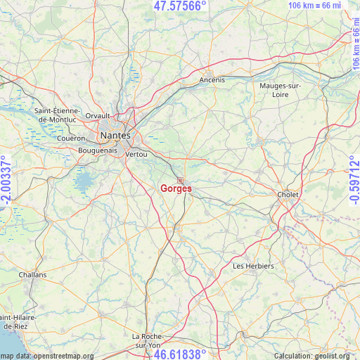
Gorges GPS coordinates[2]
47° 5' 57.012" North, 1° 18' 0.864" West
| Map corner | latitude | longitude |
|---|---|---|
| Upper-left | 47.57566°, | -2.00337° |
| Center: | 47.09917°, | -1.30024° |
| Lower-right: | 46.61838°, | -0.59712° |
| Map W x H: | 106.4×106.4 km | = 66.1×66.1mi |
| max Lat: | 51.07786° ⇑54.2% North |
| Gorges: | 47.09917° |
| min Lat: | ⇓45.8% South 41.3874° |
| min Long | Gorges | max Long |
| -5.08615° | -1.30024° | 9.52242° |
| W 9.2%⇐ | ⇒90.8% E |
Elevation
Elevation of Gorges is 31 m = 102 ft, and this is 162.7 m = 534 ft below average elevation for this country.
| Max E: |
2333 m = 7654 ft | 89.5% |
| Avg. | 193.7 m = 635 ft | |
| Gorges | 31 m = 102 ft | |
Min E: |
-1 m = -3 ft | 10.5% |
See also: France elevation on elevation.city.
Geographical zone
Gorges is located in North temperate zone (between Tropic of Cancer and the Arctic Circle). Distance of this North polar circle is 2164.2 km =1344.8 mi to North.| Distance of | km | miles | from Gorges |
|---|---|---|---|
| North Pole | 4770.1 | 2964 | to North |
| Arctic Circle | 2164.2 | 1344.8 | to North |
| Tropic Cancer | 2631 | 1634.8 | to South |
| Equator | 5236.9 | 3254.1 | to South |


Nearby cities:
15 places around Gorges: (largest is in red/bold)
• Aigrefeuille-sur-Maine
8.1 km =5 mi,  253°
253°
• Clisson
1.9 km =1.2 mi,  135°
135°
• Cugand
5.4 km =3.4 mi, 138°
• Gétigné
4.7 km =2.9 mi,  122°
122°
• La Bernardière
6.1 km =3.8 mi,  154°
154°
• La Chapelle-Heulin
9.1 km =5.7 mi,  340°
340°
• Le Pallet
5.1 km =3.2 mi,  328°
328°
• Maisdon-sur-Sèvre
6 km =3.7 mi,  267°
267°
• Monnières
5.5 km =3.4 mi,  313°
313°
• Mouzillon
4.8 km =3 mi,  16°
16°
• Remouillé
7.5 km =4.7 mi,  230°
230°
• Saint-Crespin-sur-Moine
8.6 km =5.3 mi,  89°
89°
• Saint-Hilaire-de-Clisson
4.1 km =2.5 mi,  187°
187°
• Saint-Lumine-de-Clisson
3.1 km =1.9 mi,  237°
237°
• Vallet
7.5 km =4.7 mi, 20°
Sources, notices
• [Note1] Compared only with cities in France existing in our database
• [Src1] Map data: © OpenStreetMap contributors (CC-BY-SA)
• [Src2] Other city data from geonames.org with taken over terms of usage.
• [Src3] Geographical zone / Annual Mean Temperature by Robert A. Rohde @ Wikipedia
