Béard-Géovreissiat geodata
Béard-Géovreissiat (Auvergne-Rhône-Alpes) is a populated place; located in France in Europe/Paris (GMT+2) time zone. With population of 775 people, there are 10884 cities with bigger population in this country. Compared to other cities in France, 63.7% of cities are located further ↑North; 83.3% of cities are located further ←West and 93.1% of cities have lower elevation than Béard-Géovreissiat. Note1
Administrative division(s):
- Level 1: Auvergne-Rhône-Alpes
- Level 2: Département de l'Ain
- Level 3: Arrondissement de Nantua
- Level 4: Béard-Géovreissiat


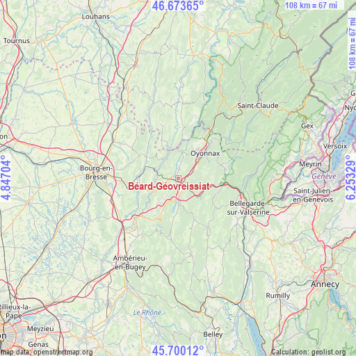
Béard-Géovreissiat GPS coordinates[2]
46° 11' 20.544" North, 5° 33' 0.576" East
| Map corner | latitude | longitude |
|---|---|---|
| Upper-left | 46.67365°, | 4.84704° |
| Center: | 46.18904°, | 5.55016° |
| Lower-right: | 45.70012°, | 6.25329° |
| Map W x H: | 108.2×108.2 km | = 67.2×67.2mi |
| max Lat: | 51.07786° ⇑63.7% North |
| Béard-Géovreissiat: | 46.18904° |
| min Lat: | ⇓36.3% South 41.3874° |
| min Long | Béard-Géovrei | max Long |
| -5.08615° | 5.55016° | 9.52242° |
| W 83.3%⇐ | ⇒16.7% E |
Elevation
Elevation of Béard-Géovreissiat is 509 m = 1670 ft, and this is 315.3 m = 1034 ft above average elevation for this country.
| Max E: |
2333 m = 7654 ft | 6.9% |
| Béard-Géovreissiat | 509 m 1670 ft | |
| Avg. | 193.7 m = 635 ft | |
Min E: |
-1 m = -3 ft | 93.1% |
See also: France elevation on elevation.city.
Geographical zone
Béard-Géovreissiat is located in North temperate zone (between Tropic of Cancer and the Arctic Circle). Distance of this North polar circle is 2265.4 km =1407.7 mi to North.| Distance of | km | miles | from Béard-Géovreissiat |
|---|---|---|---|
| North Pole | 4871.3 | 3026.9 | to North |
| Arctic Circle | 2265.4 | 1407.7 | to North |
| Tropic Cancer | 2529.8 | 1571.9 | to South |
| Equator | 5135.7 | 3191.2 | to South |


Nearby cities:
15 places around Béard-Géovreissiat: (largest is in red/bold)
• Bellignat
8.5 km =5.3 mi,  45°
45°
• Brion
1.8 km =1.1 mi,  177°
177°
• Corveissiat
8.1 km =5 mi,  319°
319°
• Granges
6.8 km =4.2 mi, 324°
• Groissiat
5.8 km =3.6 mi, 50°
• Géovreisset
9.2 km =5.7 mi,  34°
34°
• Izernore
2.7 km =1.7 mi,  2°
2°
• Les Neyrolles
8.3 km =5.2 mi,  129°
129°
• Maillat
7 km =4.3 mi,  185°
185°
• Martignat
5.2 km =3.2 mi,  63°
63°
• Montréal-la-Cluse
2.6 km =1.6 mi,  103°
103°
• Nantua
5.8 km =3.6 mi, 132°
• Port
3.1 km =1.9 mi,  153°
153°
• Saint-Martin-du-Frêne
5.9 km =3.7 mi, 179°
• Thoirette
9.1 km =5.7 mi,  349°
349°
Sources, notices
• [Note1] Compared only with cities in France existing in our database
• [Src1] Map data: © OpenStreetMap contributors (CC-BY-SA)
• [Src2] Other city data from geonames.org with taken over terms of usage.
• [Src3] Geographical zone / Annual Mean Temperature by Robert A. Rohde @ Wikipedia
