Thoirette geodata
Thoirette (Bourgogne-Franche-Comté) is a populated place; located in France in Europe/Paris (GMT+2) time zone. With population of 557 people, there are 14072 cities with bigger population in this country. Compared to other cities in France, 62.6% of cities are located further ↑North; 83.2% of cities are located further ←West and 80.3% of cities have lower elevation than Thoirette. Note1
Administrative division(s):
- Level 1: Bourgogne-Franche-Comté
- Level 2: Jura
- Level 3: Arrondissement de Lons-le-Saunier
- Level 4: Thoirette-Coisia


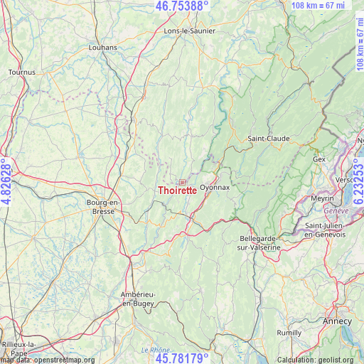
Thoirette GPS coordinates[2]
46° 16' 11.964" North, 5° 31' 45.84" East
| Map corner | latitude | longitude |
|---|---|---|
| Upper-left | 46.75388°, | 4.82628° |
| Center: | 46.26999°, | 5.5294° |
| Lower-right: | 45.78179°, | 6.23253° |
| Map W x H: | 108.1×108.1 km | = 67.2×67.2mi |
| max Lat: | 51.07786° ⇑62.6% North |
| Thoirette: | 46.26999° |
| min Lat: | ⇓37.4% South 41.3874° |
| min Long | Thoirette | max Long |
| -5.08615° | 5.5294° | 9.52242° |
| W 83.2%⇐ | ⇒16.8% E |
Elevation
Elevation of Thoirette is 293 m = 961 ft, and this is 99.3 m = 326 ft above average elevation for this country.
| Max E: |
2333 m = 7654 ft | 19.7% |
| Thoirette | 293 m 961 ft | |
| Avg. | 193.7 m = 635 ft | |
Min E: |
-1 m = -3 ft | 80.3% |
See also: France elevation on elevation.city.
Geographical zone
Thoirette is located in North temperate zone (between Tropic of Cancer and the Arctic Circle). Distance of this North polar circle is 2256.4 km =1402.1 mi to North.| Distance of | km | miles | from Thoirette |
|---|---|---|---|
| North Pole | 4862.3 | 3021.3 | to North |
| Arctic Circle | 2256.4 | 1402.1 | to North |
| Tropic Cancer | 2538.8 | 1577.5 | to South |
| Equator | 5144.7 | 3196.8 | to South |


Nearby cities:
15 places around Thoirette: (largest is in red/bold)
• Aromas
4.6 km =2.9 mi,  304°
304°
• Bellignat
8.2 km =5.1 mi,  111°
111°
• Brion
10.9 km =6.8 mi,  171°
171°
• Béard-Géovreissiat
9.1 km =5.7 mi, 169°
• Chavannes-sur-Suran
7.8 km =4.8 mi,  264°
264°
• Corveissiat
4.6 km =2.9 mi,  231°
231°
• Cuisiat
11.4 km =7.1 mi,  287°
287°
• Granges
4.2 km =2.6 mi,  214°
214°
• Groissiat
8 km =5 mi,  131°
131°
• Géovreisset
7 km =4.3 mi,  102°
102°
• Izernore
6.5 km =4 mi,  164°
164°
• Martignat
9.2 km =5.7 mi,  137°
137°
• Montréal-la-Cluse
10.5 km =6.5 mi, 156°
• Oyonnax
9.9 km =6.2 mi, 96°
• Simandre-sur-Suran
9.8 km =6.1 mi,  240°
240°
Sources, notices
• [Note1] Compared only with cities in France existing in our database
• [Src1] Map data: © OpenStreetMap contributors (CC-BY-SA)
• [Src2] Other city data from geonames.org with taken over terms of usage.
• [Src3] Geographical zone / Annual Mean Temperature by Robert A. Rohde @ Wikipedia
