Galgon geodata
Galgon (Nouvelle-Aquitaine) is a populated place; located in France in Europe/Paris (GMT+2) time zone. With population of 2,665 people, there are 3664 cities with bigger population in this country. Compared to other cities in France, 79.8% of cities are located further ↑North; 80.5% of cities are located further →East and 91.2% of cities have higher elevation than Galgon. Note1
Administrative division(s):
- Level 1: Nouvelle-Aquitaine
- Level 2: Gironde
- Level 3: Arrondissement de Libourne
- Level 4: Galgon


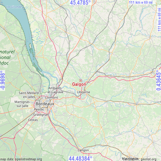
Galgon GPS coordinates[2]
44° 58' 59.988" North, 0° 16' 0.012" West
| Map corner | latitude | longitude |
|---|---|---|
| Upper-left | 45.4785°, | -0.9698° |
| Center: | 44.98333°, | -0.26667° |
| Lower-right: | 44.48384°, | 0.43645° |
| Map W x H: | 110.6×110.6 km | = 68.7×68.7mi |
| max Lat: | 51.07786° ⇑79.8% North |
| Galgon: | 44.98333° |
| min Lat: | ⇓20.2% South 41.3874° |
| min Long | Galgon | max Long |
| -5.08615° | -0.26667° | 9.52242° |
| W 19.5%⇐ | ⇒80.5% E |
Elevation
Elevation of Galgon is 27 m = 89 ft, and this is 166.7 m = 547 ft below average elevation for this country.
| Max E: |
2333 m = 7654 ft | 91.2% |
| Avg. | 193.7 m = 635 ft | |
| Galgon | 27 m = 89 ft | |
Min E: |
-1 m = -3 ft | 8.8% |
See also: France elevation on elevation.city.
Geographical zone
Galgon is located in North temperate zone (between Tropic of Cancer and the Arctic Circle). Distance of this Northern Tropic circle is 2395.8 km =1488.7 mi to South.| Distance of | km | miles | from Galgon |
|---|---|---|---|
| North Pole | 5005.4 | 3110.2 | to North |
| Arctic Circle | 2399.5 | 1491 | to North |
| Tropic Cancer | 2395.8 | 1488.7 | to South |
| Equator | 5001.7 | 3107.9 | to South |


Nearby cities:
15 places around Galgon: (largest is in red/bold)
• Bonzac
4.3 km =2.7 mi,  64°
64°
• Cadillac-en-Fronsadais
8.5 km =5.3 mi,  257°
257°
• Fronsac
7.4 km =4.6 mi,  180°
180°
• Les Billaux
4.5 km =2.8 mi,  144°
144°
• Libourne
7.8 km =4.8 mi,  166°
166°
• Lugon-et-l'Île-du-Carnay
6.3 km =3.9 mi,  240°
240°
• Pomerol
7.6 km =4.7 mi, 136°
• Périssac
5.4 km =3.4 mi,  313°
313°
• Sablons
8.6 km =5.3 mi,  49°
49°
• Saint-Ciers-d’Abzac
5.6 km =3.5 mi,  0°
0°
• Saint-Denis-de-Pile
5.6 km =3.5 mi,  70°
70°
• Saint-Michel-de-Fronsac
6.8 km =4.2 mi,  215°
215°
• Savignac-de-l'Isle
2.6 km =1.6 mi,  90°
90°
• Villegouge
3.2 km =2 mi,  234°
234°
• Vérac
5.2 km =3.2 mi,  270°
270°
Sources, notices
• [Note1] Compared only with cities in France existing in our database
• [Src1] Map data: © OpenStreetMap contributors (CC-BY-SA)
• [Src2] Other city data from geonames.org with taken over terms of usage.
• [Src3] Geographical zone / Annual Mean Temperature by Robert A. Rohde @ Wikipedia
