Libourne geodata
Libourne (Nouvelle-Aquitaine) is a seat of a third-order administrative division; located in France in Europe/Paris (GMT+2) time zone. With population of 24,240 people, there are 365 cities with bigger population in this country. Compared to other cities in France, 80.4% of cities are located further ↑North; 80.2% of cities are located further →East and 97.4% of cities have higher elevation than Libourne. Note1
Administrative division(s):
- Level 1: Nouvelle-Aquitaine
- Level 2: Gironde
- Level 3: Arrondissement de Libourne
- Level 4: Libourne


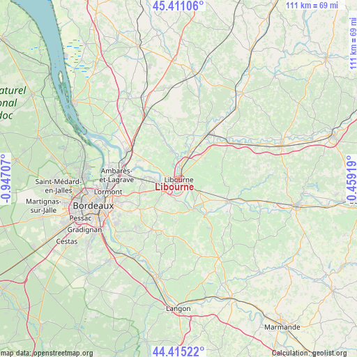
Libourne GPS coordinates[2]
44° 54' 55.08" North, 0° 14' 38.184" West
| Map corner | latitude | longitude |
|---|---|---|
| Upper-left | 45.41106°, | -0.94707° |
| Center: | 44.9153°, | -0.24394° |
| Lower-right: | 44.41522°, | 0.45919° |
| Map W x H: | 110.7×110.7 km | = 68.8×68.8mi |
| max Lat: | 51.07786° ⇑80.4% North |
| Libourne: | 44.9153° |
| min Lat: | ⇓19.6% South 41.3874° |
| min Long | Libourne | max Long |
| -5.08615° | -0.24394° | 9.52242° |
| W 19.8%⇐ | ⇒80.2% E |
Elevation
Elevation of Libourne is 10 m = 33 ft, and this is 183.7 m = 603 ft below average elevation for this country.
| Max E: |
2333 m = 7654 ft | 97.4% |
| Avg. | 193.7 m = 635 ft | |
| Libourne | 10 m = 33 ft | |
Min E: |
-1 m = -3 ft | 2.6% |
See also: France elevation on elevation.city.
Geographical zone
Libourne is located in North temperate zone (between Tropic of Cancer and the Arctic Circle). Distance of this Northern Tropic circle is 2388.2 km =1484 mi to South.| Distance of | km | miles | from Libourne |
|---|---|---|---|
| North Pole | 5012.9 | 3114.9 | to North |
| Arctic Circle | 2407.1 | 1495.7 | to North |
| Tropic Cancer | 2388.2 | 1484 | to South |
| Equator | 4994.1 | 3103.2 | to South |


Nearby cities:
15 places around Libourne: (largest is in red/bold)
• Arveyres
4.7 km =2.9 mi,  221°
221°
• Fronsac
1.8 km =1.1 mi,  274°
274°
• Galgon
7.8 km =4.8 mi,  346°
346°
• Génissac
7.3 km =4.5 mi,  183°
183°
• Les Billaux
3.9 km =2.4 mi,  12°
12°
• Lugon-et-l'Île-du-Carnay
8.5 km =5.3 mi,  301°
301°
• Montagne
8.9 km =5.5 mi,  77°
77°
• Moulon
7.6 km =4.7 mi,  163°
163°
• Pomerol
4 km =2.5 mi,  59°
59°
• Saint-Michel-de-Fronsac
6.1 km =3.8 mi,  289°
289°
• Saint-Sulpice-de-Faleyrens
7.2 km =4.5 mi,  138°
138°
• Saint-Émilion
8.2 km =5.1 mi,  115°
115°
• Savignac-de-l'Isle
7.6 km =4.7 mi, 6°
• Vayres
6 km =3.7 mi,  253°
253°
• Villegouge
7.2 km =4.5 mi,  322°
322°
Sources, notices
• [Note1] Compared only with cities in France existing in our database
• [Src1] Map data: © OpenStreetMap contributors (CC-BY-SA)
• [Src2] Other city data from geonames.org with taken over terms of usage.
• [Src3] Geographical zone / Annual Mean Temperature by Robert A. Rohde @ Wikipedia
