Pulligny geodata
Pulligny (Grand Est) is a populated place; located in France in Europe/Paris (GMT+2) time zone. With population of 1,205 people, there are 7504 cities with bigger population in this country. Compared to other cities in France, 69.3% of cities are located further ↓South; 88.8% of cities are located further ←West and 79.8% of cities have lower elevation than Pulligny. Note1
Administrative division(s):
- Level 1: Grand Est
- Level 2: Meurthe-et-Moselle
- Level 3: Arrondissement de Nancy
- Level 4: Pulligny


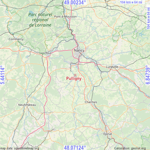
Pulligny GPS coordinates[2]
48° 32' 20.148" North, 6° 8' 39.336" East
| Map corner | latitude | longitude |
|---|---|---|
| Upper-left | 49.00234°, | 5.44114° |
| Center: | 48.53893°, | 6.14426° |
| Lower-right: | 48.07124°, | 6.84739° |
| Map W x H: | 103.5×103.5 km | = 64.3×64.3mi |
| max Lat: | 51.07786° ⇑30.7% North |
| Pulligny: | 48.53893° |
| min Lat: | ⇓69.3% South 41.3874° |
| min Long | Pulligny | max Long |
| -5.08615° | 6.14426° | 9.52242° |
| W 88.8%⇐ | ⇒11.2% E |
Elevation
Elevation of Pulligny is 288 m = 945 ft, and this is 94.3 m = 309 ft above average elevation for this country.
| Max E: |
2333 m = 7654 ft | 20.2% |
| Pulligny | 288 m 945 ft | |
| Avg. | 193.7 m = 635 ft | |
Min E: |
-1 m = -3 ft | 79.8% |
See also: France elevation on elevation.city.
Geographical zone
Pulligny is located in North temperate zone (between Tropic of Cancer and the Arctic Circle). Distance of this North polar circle is 2004.2 km =1245.4 mi to North.| Distance of | km | miles | from Pulligny |
|---|---|---|---|
| North Pole | 4610 | 2864.5 | to North |
| Arctic Circle | 2004.2 | 1245.4 | to North |
| Tropic Cancer | 2791.1 | 1734.3 | to South |
| Equator | 5397 | 3353.5 | to South |


Nearby cities:
15 places around Pulligny: (largest is in red/bold)
• Bainville-sur-Madon
6.4 km =4 mi,  326°
326°
• Benney
6.2 km =3.9 mi,  117°
117°
• Ceintrey
2.1 km =1.3 mi,  138°
138°
• Flavigny-sur-Moselle
4.4 km =2.7 mi,  47°
47°
• Frolois
3.2 km =2 mi,  335°
335°
• Ludres
9.2 km =5.7 mi,  10°
10°
• Maizières
7.9 km =4.9 mi,  308°
308°
• Messein
8.1 km =5 mi,  357°
357°
• Méréville
5.8 km =3.6 mi,  4°
4°
• Pont-Saint-Vincent
8.1 km =5 mi, 335°
• Richardménil
6.3 km =3.9 mi,  16°
16°
• Tantonville
7.7 km =4.8 mi,  183°
183°
• Tonnoy
8 km =5 mi,  79°
79°
• Vézelise
7.1 km =4.4 mi,  215°
215°
• Xeuilley
4.6 km =2.9 mi, 312°
Sources, notices
• [Note1] Compared only with cities in France existing in our database
• [Src1] Map data: © OpenStreetMap contributors (CC-BY-SA)
• [Src2] Other city data from geonames.org with taken over terms of usage.
• [Src3] Geographical zone / Annual Mean Temperature by Robert A. Rohde @ Wikipedia
