Francheval geodata
Francheval (Grand Est) is a populated place; located in France in Europe/Paris (GMT+2) time zone. With population of 589 people, there are 13496 cities with bigger population in this country. Compared to other cities in France, 91.5% of cities are located further ↓South; 78.2% of cities are located further ←West and 68.1% of cities have lower elevation than Francheval. Note1
Administrative division(s):
- Level 1: Grand Est
- Level 2: Ardennes
- Level 3: Arrondissement de Sedan
- Level 4: Francheval


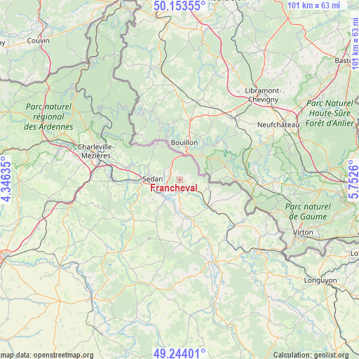
Francheval GPS coordinates[2]
49° 42' 3.276" North, 5° 2' 58.128" East
| Map corner | latitude | longitude |
|---|---|---|
| Upper-left | 50.15355°, | 4.34635° |
| Center: | 49.70091°, | 5.04948° |
| Lower-right: | 49.24401°, | 5.7526° |
| Map W x H: | 101.1×101.1 km | = 62.8×62.8mi |
| max Lat: | 51.07786° ⇑8.5% North |
| Francheval: | 49.70091° |
| min Lat: | ⇓91.5% South 41.3874° |
| min Long | Francheval | max Long |
| -5.08615° | 5.04948° | 9.52242° |
| W 78.2%⇐ | ⇒21.8% E |
Elevation
Elevation of Francheval is 210 m = 689 ft, and this is 16.3 m = 53 ft above average elevation for this country.
| Max E: |
2333 m = 7654 ft | 31.9% |
| Francheval | 210 m 689 ft | |
| Avg. | 193.7 m = 635 ft | |
Min E: |
-1 m = -3 ft | 68.1% |
See also: France elevation on elevation.city.
Geographical zone
Francheval is located in North temperate zone (between Tropic of Cancer and the Arctic Circle). Distance of this North polar circle is 1875 km =1165.1 mi to North.| Distance of | km | miles | from Francheval |
|---|---|---|---|
| North Pole | 4480.8 | 2784.2 | to North |
| Arctic Circle | 1875 | 1165.1 | to North |
| Tropic Cancer | 2920.3 | 1814.6 | to South |
| Equator | 5526.2 | 3433.8 | to South |


Nearby cities:
15 places around Francheval: (largest is in red/bold)
• Balan
6.2 km =3.9 mi,  257°
257°
• Bazeilles
5.8 km =3.6 mi,  242°
242°
• Douzy
3.4 km =2.1 mi,  189°
189°
• Floing
8.9 km =5.5 mi,  285°
285°
• Givonne
5 km =3.1 mi,  296°
296°
• Glaire
9.7 km =6 mi,  280°
280°
• Messincourt
7.9 km =4.9 mi,  106°
106°
• Mouzon
10.6 km =6.6 mi,  169°
169°
• Noyers-Pont-Maugis
9.2 km =5.7 mi, 241°
• Pouru-Saint-Remy
3.1 km =1.9 mi,  128°
128°
• Pure
9.6 km =6 mi, 108°
• Remilly-Aillicourt
6.7 km =4.2 mi,  216°
216°
• Saint-Menges
9.8 km =6.1 mi, 295°
• Sedan
7.9 km =4.9 mi,  270°
270°
• Wadelincourt
8 km =5 mi, 257°
Sources, notices
• [Note1] Compared only with cities in France existing in our database
• [Src1] Map data: © OpenStreetMap contributors (CC-BY-SA)
• [Src2] Other city data from geonames.org with taken over terms of usage.
• [Src3] Geographical zone / Annual Mean Temperature by Robert A. Rohde @ Wikipedia
