Foulain geodata
Foulain (Grand Est) is a populated place; located in France in Europe/Paris (GMT+2) time zone. With population of 727 people, there are 11442 cities with bigger population in this country. Compared to other cities in France, 60% of cities are located further ↓South; 79.9% of cities are located further ←West and 80.4% of cities have lower elevation than Foulain. Note1
Administrative division(s):
- Level 1: Grand Est
- Level 2: Haute-Marne
- Level 3: Arrondissement de Chaumont
- Level 4: Foulain


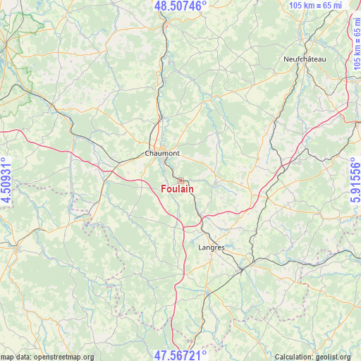
Foulain GPS coordinates[2]
48° 2' 22.128" North, 5° 12' 44.784" East
| Map corner | latitude | longitude |
|---|---|---|
| Upper-left | 48.50746°, | 4.50931° |
| Center: | 48.03948°, | 5.21244° |
| Lower-right: | 47.56721°, | 5.91556° |
| Map W x H: | 104.5×104.5 km | = 64.9×64.9mi |
| max Lat: | 51.07786° ⇑40% North |
| Foulain: | 48.03948° |
| min Lat: | ⇓60% South 41.3874° |
| min Long | Foulain | max Long |
| -5.08615° | 5.21244° | 9.52242° |
| W 79.9%⇐ | ⇒20.1% E |
Elevation
Elevation of Foulain is 294 m = 965 ft, and this is 100.3 m = 329 ft above average elevation for this country.
| Max E: |
2333 m = 7654 ft | 19.6% |
| Foulain | 294 m 965 ft | |
| Avg. | 193.7 m = 635 ft | |
Min E: |
-1 m = -3 ft | 80.4% |
See also: France elevation on elevation.city.
Geographical zone
Foulain is located in North temperate zone (between Tropic of Cancer and the Arctic Circle). Distance of this North polar circle is 2059.7 km =1279.8 mi to North.| Distance of | km | miles | from Foulain |
|---|---|---|---|
| North Pole | 4665.6 | 2899.1 | to North |
| Arctic Circle | 2059.7 | 1279.8 | to North |
| Tropic Cancer | 2735.6 | 1699.8 | to South |
| Equator | 5341.5 | 3319.1 | to South |


Nearby cities:
15 places around Foulain: (largest is in red/bold)
• Arc-en-Barrois
18.3 km =11.4 mi,  236°
236°
• Biesles
8 km =5 mi,  49°
49°
• Bologne
18.6 km =11.6 mi,  343°
343°
• Chamarandes-Choignes
6.7 km =4.2 mi,  316°
316°
• Chaumont
9.6 km =6 mi,  326°
326°
• Châteauvillain
21.9 km =13.6 mi,  269°
269°
• Humes-Jorquenay
16.4 km =10.2 mi,  161°
161°
• Is-en-Bassigny
17.5 km =10.9 mi,  92°
92°
• Jonchery
14.3 km =8.9 mi, 318°
• Langres
21.6 km =13.4 mi, 155°
• Montsaon
14.1 km =8.8 mi,  290°
290°
• Nogent-le-Bas
9.2 km =5.7 mi,  103°
103°
• Rolampont
11.4 km =7.1 mi,  151°
151°
• Val-de-Meuse
21.8 km =13.5 mi, 101°
• Villiers-le-Sec
13.3 km =8.3 mi,  302°
302°
Sources, notices
• [Note1] Compared only with cities in France existing in our database
• [Src1] Map data: © OpenStreetMap contributors (CC-BY-SA)
• [Src2] Other city data from geonames.org with taken over terms of usage.
• [Src3] Geographical zone / Annual Mean Temperature by Robert A. Rohde @ Wikipedia
