Chaumont geodata
Chaumont (Grand Est) is a seat of a second-order administrative division; located in France in Europe/Paris (GMT+2) time zone. With population of 28,981 people, there are 288 cities with bigger population in this country. Compared to other cities in France, 61.4% of cities are located further ↓South; 79.1% of cities are located further ←West and 83.1% of cities have lower elevation than Chaumont. Note1
Administrative division(s):
- Level 1: Grand Est
- Level 2: Haute-Marne
- Level 3: Arrondissement de Chaumont
- Level 4: Chaumont


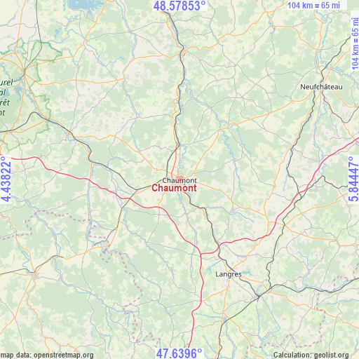
Chaumont GPS coordinates[2]
48° 6' 40.356" North, 5° 8' 28.824" East
| Map corner | latitude | longitude |
|---|---|---|
| Upper-left | 48.57853°, | 4.43822° |
| Center: | 48.11121°, | 5.14134° |
| Lower-right: | 47.6396°, | 5.84447° |
| Map W x H: | 104.4×104.4 km | = 64.9×64.9mi |
| max Lat: | 51.07786° ⇑38.6% North |
| Chaumont: | 48.11121° |
| min Lat: | ⇓61.4% South 41.3874° |
| min Long | Chaumont | max Long |
| -5.08615° | 5.14134° | 9.52242° |
| W 79.1%⇐ | ⇒20.9% E |
Elevation
Elevation of Chaumont is 322 m = 1056 ft, and this is 128.3 m = 421 ft above average elevation for this country.
| Max E: |
2333 m = 7654 ft | 16.9% |
| Chaumont | 322 m 1056 ft | |
| Avg. | 193.7 m = 635 ft | |
Min E: |
-1 m = -3 ft | 83.1% |
See also: France elevation on elevation.city.
Geographical zone
Chaumont is located in North temperate zone (between Tropic of Cancer and the Arctic Circle). Distance of this North polar circle is 2051.7 km =1274.9 mi to North.| Distance of | km | miles | from Chaumont |
|---|---|---|---|
| North Pole | 4657.6 | 2894.1 | to North |
| Arctic Circle | 2051.7 | 1274.9 | to North |
| Tropic Cancer | 2743.5 | 1704.7 | to South |
| Equator | 5349.5 | 3324 | to South |


Nearby cities:
15 places around Chaumont: (largest is in red/bold)
• Andelot-Blancheville
19.4 km =12.1 mi,  37°
37°
• Arc-en-Barrois
20.7 km =12.9 mi,  208°
208°
• Biesles
11.7 km =7.3 mi,  103°
103°
• Bologne
9.9 km =6.2 mi,  0°
0°
• Chamarandes-Choignes
3.2 km =2 mi,  168°
168°
• Châteauvillain
18.5 km =11.5 mi,  243°
243°
• Foulain
9.6 km =6 mi,  146°
146°
• Froncles
20.7 km =12.9 mi, 0°
• Jonchery
5 km =3.1 mi,  304°
304°
• Lavilleneuve-au-Roi
16.9 km =10.5 mi,  288°
288°
• Montsaon
8.4 km =5.2 mi,  248°
248°
• Nogent-le-Bas
17.5 km =10.9 mi,  125°
125°
• Rimaucourt
21.2 km =13.2 mi, 42°
• Rolampont
20.9 km =13 mi, 149°
• Villiers-le-Sec
6 km =3.7 mi,  262°
262°
Sources, notices
• [Note1] Compared only with cities in France existing in our database
• [Src1] Map data: © OpenStreetMap contributors (CC-BY-SA)
• [Src2] Other city data from geonames.org with taken over terms of usage.
• [Src3] Geographical zone / Annual Mean Temperature by Robert A. Rohde @ Wikipedia
