Fontenoy geodata
Fontenoy (Hauts-de-France) is a populated place; located in France in Europe/Paris (GMT+2) time zone. With population of 547 people, there are 14264 cities with bigger population in this country. Compared to other cities in France, 88% of cities are located further ↓South; 60.6% of cities are located further ←West and 79.8% of cities have higher elevation than Fontenoy. Note1
Administrative division(s):
- Level 1: Hauts-de-France
- Level 2: Département de l'Aisne
- Level 3: Arrondissement de Soissons
- Level 4: Fontenoy


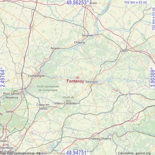
Fontenoy GPS coordinates[2]
49° 24' 25.74" North, 3° 12' 2.736" East
| Map corner | latitude | longitude |
|---|---|---|
| Upper-left | 49.86253°, | 2.49764° |
| Center: | 49.40715°, | 3.20076° |
| Lower-right: | 48.94751°, | 3.90389° |
| Map W x H: | 101.7×101.7 km | = 63.2×63.2mi |
| max Lat: | 51.07786° ⇑12% North |
| Fontenoy: | 49.40715° |
| min Lat: | ⇓88% South 41.3874° |
| min Long | Fontenoy | max Long |
| -5.08615° | 3.20076° | 9.52242° |
| W 60.6%⇐ | ⇒39.4% E |
Elevation
Elevation of Fontenoy is 55 m = 180 ft, and this is 138.7 m = 455 ft below average elevation for this country.
| Max E: |
2333 m = 7654 ft | 79.8% |
| Avg. | 193.7 m = 635 ft | |
| Fontenoy | 55 m = 180 ft | |
Min E: |
-1 m = -3 ft | 20.2% |
See also: France elevation on elevation.city.
Geographical zone
Fontenoy is located in North temperate zone (between Tropic of Cancer and the Arctic Circle). Distance of this North polar circle is 1907.6 km =1185.3 mi to North.| Distance of | km | miles | from Fontenoy |
|---|---|---|---|
| North Pole | 4513.5 | 2804.6 | to North |
| Arctic Circle | 1907.6 | 1185.3 | to North |
| Tropic Cancer | 2887.6 | 1794.3 | to South |
| Equator | 5493.6 | 3413.6 | to South |


Nearby cities:
15 places around Fontenoy: (largest is in red/bold)
• Ambleny
3.2 km =2 mi,  201°
201°
• Autrêches
6.9 km =4.3 mi,  307°
307°
• Berny-Rivière
4.4 km =2.7 mi,  271°
271°
• Courmelles
10.6 km =6.6 mi,  130°
130°
• Cuffies
8.7 km =5.4 mi,  92°
92°
• Jaulzy
9.9 km =6.2 mi,  262°
262°
• Mercin-et-Vaux
6.5 km =4 mi,  121°
121°
• Montigny-Lengrain
8.4 km =5.2 mi,  242°
242°
• Pasly
6.9 km =4.3 mi,  95°
95°
• Pernant
4 km =2.5 mi,  135°
135°
• Pommiers
5.5 km =3.4 mi,  106°
106°
• Ressons-le-Long
4.3 km =2.7 mi, 239°
• Soissons
9.3 km =5.8 mi, 107°
• Vauxbuin
8.6 km =5.3 mi, 128°
• Vic-sur-Aisne
6.4 km =4 mi, 268°
Sources, notices
• [Note1] Compared only with cities in France existing in our database
• [Src1] Map data: © OpenStreetMap contributors (CC-BY-SA)
• [Src2] Other city data from geonames.org with taken over terms of usage.
• [Src3] Geographical zone / Annual Mean Temperature by Robert A. Rohde @ Wikipedia
