Autrêches geodata
Autrêches (Hauts-de-France) is a populated place; located in France in Europe/Paris (GMT+2) time zone. With population of 703 people, there are 11764 cities with bigger population in this country. Compared to other cities in France, 88.5% of cities are located further ↓South; 59.6% of cities are located further ←West and 67.8% of cities have higher elevation than Autrêches. Note1
Administrative division(s):
- Level 1: Hauts-de-France
- Level 2: Département de l'Oise
- Level 3: Arrondissement de Compiègne
- Level 4: Autrêches


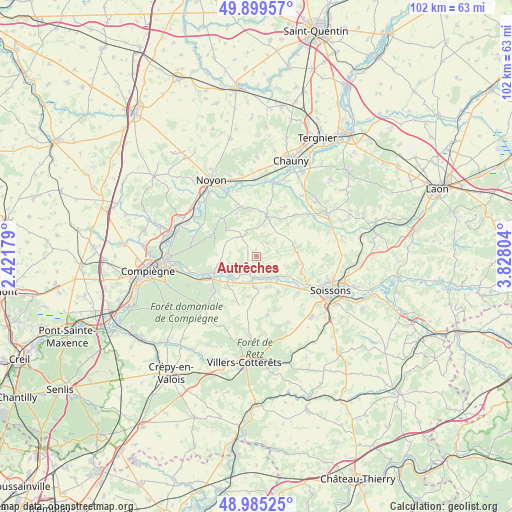
Autrêches GPS coordinates[2]
49° 26' 40.344" North, 3° 7' 29.712" East
| Map corner | latitude | longitude |
|---|---|---|
| Upper-left | 49.89957°, | 2.42179° |
| Center: | 49.44454°, | 3.12492° |
| Lower-right: | 48.98525°, | 3.82804° |
| Map W x H: | 101.7×101.7 km | = 63.2×63.2mi |
| max Lat: | 51.07786° ⇑11.5% North |
| Autrêches: | 49.44454° |
| min Lat: | ⇓88.5% South 41.3874° |
| min Long | Autrêches | max Long |
| -5.08615° | 3.12492° | 9.52242° |
| W 59.6%⇐ | ⇒40.4% E |
Elevation
Elevation of Autrêches is 83 m = 272 ft, and this is 110.7 m = 363 ft below average elevation for this country.
| Max E: |
2333 m = 7654 ft | 67.8% |
| Avg. | 193.7 m = 635 ft | |
| Autrêches | 83 m = 272 ft | |
Min E: |
-1 m = -3 ft | 32.2% |
See also: France elevation on elevation.city.
Geographical zone
Autrêches is located in North temperate zone (between Tropic of Cancer and the Arctic Circle). Distance of this North polar circle is 1903.5 km =1182.8 mi to North.| Distance of | km | miles | from Autrêches |
|---|---|---|---|
| North Pole | 4509.3 | 2801.9 | to North |
| Arctic Circle | 1903.5 | 1182.8 | to North |
| Tropic Cancer | 2891.8 | 1796.9 | to South |
| Equator | 5497.7 | 3416.1 | to South |


Nearby cities:
15 places around Autrêches: (largest is in red/bold)
• Ambleny
8.3 km =5.2 mi,  148°
148°
• Attichy
6.6 km =4.1 mi,  235°
235°
• Berneuil-sur-Aisne
9 km =5.6 mi,  248°
248°
• Berny-Rivière
4.2 km =2.6 mi,  164°
164°
• Blérancourt
8.2 km =5.1 mi,  12°
12°
• Carlepont
10.7 km =6.6 mi,  316°
316°
• Couloisy
8.7 km =5.4 mi,  234°
234°
• Cuts
9.9 km =6.2 mi,  348°
348°
• Fontenoy
6.9 km =4.3 mi,  127°
127°
• Jaulzy
7 km =4.3 mi,  218°
218°
• Montigny-Lengrain
8.3 km =5.2 mi,  193°
193°
• Ressons-le-Long
6.6 km =4.1 mi, 164°
• Tracy-le-Mont
8.9 km =5.5 mi,  290°
290°
• Tracy-le-Val
9.7 km =6 mi,  300°
300°
• Vic-sur-Aisne
4.4 km =2.7 mi, 192°
Sources, notices
• [Note1] Compared only with cities in France existing in our database
• [Src1] Map data: © OpenStreetMap contributors (CC-BY-SA)
• [Src2] Other city data from geonames.org with taken over terms of usage.
• [Src3] Geographical zone / Annual Mean Temperature by Robert A. Rohde @ Wikipedia
