Flottemanville-Hague geodata
Flottemanville-Hague (Normandy) is a populated place; located in France in Europe/Paris (GMT+2) time zone. With population of 741 people, there are 11277 cities with bigger population in this country. Compared to other cities in France, 90.8% of cities are located further ↓South; 93.6% of cities are located further →East and 58.4% of cities have lower elevation than Flottemanville-Hague. Note1
Administrative division(s):
- Level 1: Normandy
- Level 2: Manche
- Level 3: Arrondissement de Cherbourg
- Level 4: La Hague


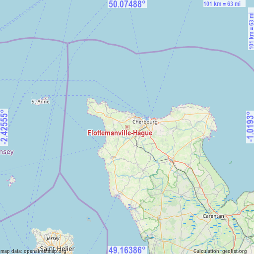
Flottemanville-Hague GPS coordinates[2]
49° 37' 17.4" North, 1° 43' 20.712" West
| Map corner | latitude | longitude |
|---|---|---|
| Upper-left | 50.07488°, | -2.42555° |
| Center: | 49.6215°, | -1.72242° |
| Lower-right: | 49.16386°, | -1.0193° |
| Map W x H: | 101.3×101.3 km | = 62.9×62.9mi |
| max Lat: | 51.07786° ⇑9.2% North |
| Flottemanville-Hague: | 49.6215° |
| min Lat: | ⇓90.8% South 41.3874° |
| min Long | Flottemanville- | max Long |
| -5.08615° | -1.72242° | 9.52242° |
| W 6.4%⇐ | ⇒93.6% E |
Elevation
Elevation of Flottemanville-Hague is 163 m = 535 ft, and this is 30.7 m = 101 ft below average elevation for this country.
| Max E: |
2333 m = 7654 ft | 41.6% |
| Avg. | 193.7 m = 635 ft | |
| Flottemanville-Hague | 163 m = 535 ft | |
Min E: |
-1 m = -3 ft | 58.4% |
See also: France elevation on elevation.city.
Geographical zone
Flottemanville-Hague is located in North temperate zone (between Tropic of Cancer and the Arctic Circle). Distance of this North polar circle is 1883.8 km =1170.5 mi to North.| Distance of | km | miles | from Flottemanville-Hague |
|---|---|---|---|
| North Pole | 4489.7 | 2789.8 | to North |
| Arctic Circle | 1883.8 | 1170.5 | to North |
| Tropic Cancer | 2911.5 | 1809.1 | to South |
| Equator | 5517.4 | 3428.4 | to South |


Nearby cities:
15 places around Flottemanville-Hague: (largest is in red/bold)
• Acqueville
2.4 km =1.5 mi,  234°
234°
• Cherbourg-Octeville
7.9 km =4.9 mi,  75°
75°
• Hardinvast
7.2 km =4.5 mi,  132°
132°
• Martinvast
5 km =3.1 mi,  124°
124°
• Nouainville
2.8 km =1.7 mi,  91°
91°
• Octeville
5.7 km =3.5 mi, 84°
• Querqueville
5.1 km =3.2 mi,  26°
26°
• Sainte-Croix-Hague
4.1 km =2.5 mi,  297°
297°
• Sideville
4.6 km =2.9 mi,  140°
140°
• Teurthéville-Hague
4.3 km =2.7 mi,  185°
185°
• Tonneville
2.5 km =1.6 mi,  12°
12°
• Urville-Nacqueville
6 km =3.7 mi,  350°
350°
• Vasteville
4.8 km =3 mi, 231°
• Virandeville
5.8 km =3.6 mi,  182°
182°
• Équeurdreville-Hainneville
5.8 km =3.6 mi,  58°
58°
Sources, notices
• [Note1] Compared only with cities in France existing in our database
• [Src1] Map data: © OpenStreetMap contributors (CC-BY-SA)
• [Src2] Other city data from geonames.org with taken over terms of usage.
• [Src3] Geographical zone / Annual Mean Temperature by Robert A. Rohde @ Wikipedia
