Cherbourg-Octeville geodata
Cherbourg-Octeville (Normandy) is a seat of a third-order administrative division; located in France in Europe/Paris (GMT+2) time zone. With population of 26,655 people, there are 322 cities with bigger population in this country. Compared to other cities in France, 91% of cities are located further ↓South; 93.1% of cities are located further →East and 99% of cities have higher elevation than Cherbourg-Octeville. Note1
Administrative division(s):
- Level 1: Normandy
- Level 2: Manche
- Level 3: Arrondissement de Cherbourg
- Level 4: Cherbourg-en-Cotentin


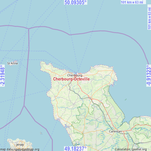
Cherbourg-Octeville GPS coordinates[2]
49° 38' 23.424" North, 1° 36' 58.896" West
| Map corner | latitude | longitude |
|---|---|---|
| Upper-left | 50.09305°, | -2.31948° |
| Center: | 49.63984°, | -1.61636° |
| Lower-right: | 49.18237°, | -0.91323° |
| Map W x H: | 101.3×101.3 km | = 62.9×62.9mi |
| max Lat: | 51.07786° ⇑9% North |
| Cherbourg-Octeville: | 49.63984° |
| min Lat: | ⇓91% South 41.3874° |
| min Long | Cherbourg-Octev | max Long |
| -5.08615° | -1.61636° | 9.52242° |
| W 6.9%⇐ | ⇒93.1% E |
Elevation
Elevation of Cherbourg-Octeville is 6 m = 20 ft, and this is 187.7 m = 616 ft below average elevation for this country.
| Max E: |
2333 m = 7654 ft | 99% |
| Avg. | 193.7 m = 635 ft | |
| Cherbourg-Octeville | 6 m = 20 ft | |
Min E: |
-1 m = -3 ft | 1% |
See also: France elevation on elevation.city.
Geographical zone
Cherbourg-Octeville is located in North temperate zone (between Tropic of Cancer and the Arctic Circle). Distance of this North polar circle is 1881.7 km =1169.2 mi to North.| Distance of | km | miles | from Cherbourg-Octeville |
|---|---|---|---|
| North Pole | 4487.6 | 2788.5 | to North |
| Arctic Circle | 1881.7 | 1169.2 | to North |
| Tropic Cancer | 2913.5 | 1810.4 | to South |
| Equator | 5519.4 | 3429.6 | to South |


Nearby cities:
15 places around Cherbourg-Octeville: (largest is in red/bold)
• Bretteville
6.5 km =4 mi,  75°
75°
• Digosville
6.6 km =4.1 mi,  98°
98°
• Flottemanville-Hague
7.9 km =4.9 mi,  255°
255°
• Hardinvast
7.2 km =4.5 mi,  198°
198°
• La Glacerie
4.6 km =2.9 mi,  147°
147°
• Le Mesnil-au-Val
7.6 km =4.7 mi,  119°
119°
• Martinvast
6 km =3.7 mi,  215°
215°
• Nouainville
5.2 km =3.2 mi,  246°
246°
• Octeville
2.5 km =1.6 mi,  232°
232°
• Querqueville
5.9 km =3.7 mi,  295°
295°
• Sideville
7.3 km =4.5 mi, 220°
• Tollevast
7.3 km =4.5 mi,  186°
186°
• Tonneville
7.1 km =4.4 mi,  273°
273°
• Tourlaville
3.6 km =2.2 mi,  92°
92°
• Équeurdreville-Hainneville
2.8 km =1.7 mi,  290°
290°
In other languages:
- In Spanish: Cherburgo-Octeville
- In France: Cherbourg
- In Italian: Cherbourg
- In Russian: Шербур-Октевиль
- In Chinese: 瑟堡-奥克特维尔
Sources, notices
• [Note1] Compared only with cities in France existing in our database
• [Src1] Map data: © OpenStreetMap contributors (CC-BY-SA)
• [Src2] Other city data from geonames.org with taken over terms of usage.
• [Src3] Geographical zone / Annual Mean Temperature by Robert A. Rohde @ Wikipedia
