Faverolles-sur-Cher geodata
Faverolles-sur-Cher (Centre) is a populated place; located in France in Europe/Paris (GMT+2) time zone. With population of 1,240 people, there are 7330 cities with bigger population in this country. Compared to other cities in France, 51.3% of cities are located further ↑North; 66.9% of cities are located further →East and 64.9% of cities have higher elevation than Faverolles-sur-Cher. Note1
Administrative division(s):
- Level 1: Centre
- Level 2: Département du Loir-et-Cher
- Level 3: Arrondissement de Romorantin-Lanthenay
- Level 4: Faverolles-sur-Cher


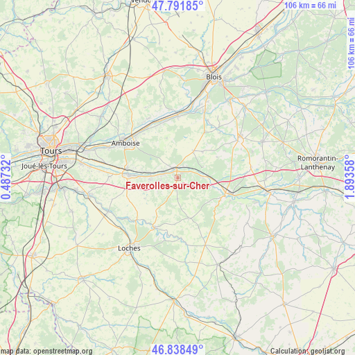
Faverolles-sur-Cher GPS coordinates[2]
47° 19' 2.352" North, 1° 11' 25.62" East
| Map corner | latitude | longitude |
|---|---|---|
| Upper-left | 47.79185°, | 0.48732° |
| Center: | 47.31732°, | 1.19045° |
| Lower-right: | 46.83849°, | 1.89358° |
| Map W x H: | 106×106 km | = 65.9×65.9mi |
| max Lat: | 51.07786° ⇑51.3% North |
| Faverolles-sur-Cher: | 47.31732° |
| min Lat: | ⇓48.7% South 41.3874° |
| min Long | Faverolles-sur- | max Long |
| -5.08615° | 1.19045° | 9.52242° |
| W 33.1%⇐ | ⇒66.9% E |
Elevation
Elevation of Faverolles-sur-Cher is 90 m = 295 ft, and this is 103.7 m = 340 ft below average elevation for this country.
| Max E: |
2333 m = 7654 ft | 64.9% |
| Avg. | 193.7 m = 635 ft | |
| Faverolles-sur-Cher | 90 m = 295 ft | |
Min E: |
-1 m = -3 ft | 35.1% |
See also: France elevation on elevation.city.
Geographical zone
Faverolles-sur-Cher is located in North temperate zone (between Tropic of Cancer and the Arctic Circle). Distance of this North polar circle is 2140 km =1329.7 mi to North.| Distance of | km | miles | from Faverolles-sur-Cher |
|---|---|---|---|
| North Pole | 4745.9 | 2949 | to North |
| Arctic Circle | 2140 | 1329.7 | to North |
| Tropic Cancer | 2655.3 | 1649.9 | to South |
| Equator | 5261.2 | 3269.2 | to South |


Nearby cities:
15 places around Faverolles-sur-Cher: (largest is in red/bold)
• Angé
4.4 km =2.7 mi,  68°
68°
• Bourré
4.3 km =2.7 mi,  39°
39°
• Chissay-en-Touraine
4.8 km =3 mi,  297°
297°
• Chisseaux
7.6 km =4.7 mi,  281°
281°
• Civray-de-Touraine
10.8 km =6.7 mi, 279°
• Francueil
8 km =5 mi,  266°
266°
• Mareuil-sur-Cher
10.8 km =6.7 mi,  104°
104°
• Monthou-sur-Cher
8.8 km =5.5 mi, 66°
• Montrichard
2.9 km =1.8 mi,  354°
354°
• Pontlevoy
9.4 km =5.8 mi,  30°
30°
• Pouillé
7.5 km =4.7 mi,  89°
89°
• Saint-Georges-sur-Cher
4.6 km =2.9 mi,  287°
287°
• Saint-Julien-de-Chédon
1.8 km =1.1 mi,  146°
146°
• Thenay
10.9 km =6.8 mi, 44°
• Thésée
8.9 km =5.5 mi, 85°
Sources, notices
• [Note1] Compared only with cities in France existing in our database
• [Src1] Map data: © OpenStreetMap contributors (CC-BY-SA)
• [Src2] Other city data from geonames.org with taken over terms of usage.
• [Src3] Geographical zone / Annual Mean Temperature by Robert A. Rohde @ Wikipedia
