Monthou-sur-Cher geodata
Monthou-sur-Cher (Centre) is a populated place; located in France in Europe/Paris (GMT+2) time zone. With population of 940 people, there are 9303 cities with bigger population in this country. Compared to other cities in France, 50.8% of cities are located further ↑North; 65.6% of cities are located further →East and 71.9% of cities have higher elevation than Monthou-sur-Cher. Note1
Administrative division(s):
- Level 1: Centre
- Level 2: Département du Loir-et-Cher
- Level 3: Arrondissement de Romorantin-Lanthenay
- Level 4: Monthou-sur-Cher


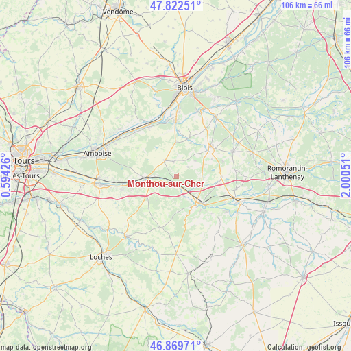
Monthou-sur-Cher GPS coordinates[2]
47° 20' 53.736" North, 1° 17' 50.568" East
| Map corner | latitude | longitude |
|---|---|---|
| Upper-left | 47.82251°, | 0.59426° |
| Center: | 47.34826°, | 1.29738° |
| Lower-right: | 46.86971°, | 2.00051° |
| Map W x H: | 105.9×105.9 km | = 65.8×65.8mi |
| max Lat: | 51.07786° ⇑50.8% North |
| Monthou-sur-Cher: | 47.34826° |
| min Lat: | ⇓49.2% South 41.3874° |
| min Long | Monthou-sur-Che | max Long |
| -5.08615° | 1.29738° | 9.52242° |
| W 34.4%⇐ | ⇒65.6% E |
Elevation
Elevation of Monthou-sur-Cher is 74 m = 243 ft, and this is 119.7 m = 393 ft below average elevation for this country.
| Max E: |
2333 m = 7654 ft | 71.9% |
| Avg. | 193.7 m = 635 ft | |
| Monthou-sur-Cher | 74 m = 243 ft | |
Min E: |
-1 m = -3 ft | 28.1% |
See also: France elevation on elevation.city.
Geographical zone
Monthou-sur-Cher is located in North temperate zone (between Tropic of Cancer and the Arctic Circle). Distance of this North polar circle is 2136.5 km =1327.6 mi to North.| Distance of | km | miles | from Monthou-sur-Cher |
|---|---|---|---|
| North Pole | 4742.4 | 2946.8 | to North |
| Arctic Circle | 2136.5 | 1327.6 | to North |
| Tropic Cancer | 2658.7 | 1652 | to South |
| Equator | 5264.6 | 3271.3 | to South |


Nearby cities:
15 places around Monthou-sur-Cher: (largest is in red/bold)
• Angé
4.4 km =2.7 mi,  244°
244°
• Bourré
5.3 km =3.3 mi,  269°
269°
• Couddes
8.2 km =5.1 mi,  77°
77°
• Faverolles-sur-Cher
8.8 km =5.5 mi,  246°
246°
• Feings
10.8 km =6.7 mi,  22°
22°
• Mareuil-sur-Cher
6.6 km =4.1 mi,  158°
158°
• Montrichard
8.4 km =5.2 mi, 266°
• Pontlevoy
5.6 km =3.5 mi,  325°
325°
• Pouillé
3.5 km =2.2 mi,  189°
189°
• Saint-Aignan
10.6 km =6.6 mi,  146°
146°
• Saint-Julien-de-Chédon
8.6 km =5.3 mi,  234°
234°
• Saint-Romain-sur-Cher
8.4 km =5.2 mi,  113°
113°
• Sambin
10 km =6.2 mi,  359°
359°
• Thenay
4.4 km =2.7 mi,  353°
353°
• Thésée
2.9 km =1.8 mi, 162°
Sources, notices
• [Note1] Compared only with cities in France existing in our database
• [Src1] Map data: © OpenStreetMap contributors (CC-BY-SA)
• [Src2] Other city data from geonames.org with taken over terms of usage.
• [Src3] Geographical zone / Annual Mean Temperature by Robert A. Rohde @ Wikipedia
