Pontlevoy geodata
Pontlevoy (Centre) is a populated place; located in France in Europe/Paris (GMT+2) time zone. With population of 1,604 people, there are 5819 cities with bigger population in this country. Compared to other cities in France, 50.2% of cities are located further ↑North; 66.1% of cities are located further →East and 61.2% of cities have higher elevation than Pontlevoy. Note1
Administrative division(s):
- Level 1: Centre
- Level 2: Département du Loir-et-Cher
- Level 3: Arrondissement de Romorantin-Lanthenay
- Level 4: Pontlevoy


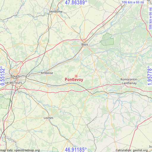
Pontlevoy GPS coordinates[2]
47° 23' 24.072" North, 1° 15' 16.74" East
| Map corner | latitude | longitude |
|---|---|---|
| Upper-left | 47.86389°, | 0.55152° |
| Center: | 47.39002°, | 1.25465° |
| Lower-right: | 46.91185°, | 1.95778° |
| Map W x H: | 105.9×105.9 km | = 65.8×65.8mi |
| max Lat: | 51.07786° ⇑50.2% North |
| Pontlevoy: | 47.39002° |
| min Lat: | ⇓49.8% South 41.3874° |
| min Long | Pontlevoy | max Long |
| -5.08615° | 1.25465° | 9.52242° |
| W 33.9%⇐ | ⇒66.1% E |
Elevation
Elevation of Pontlevoy is 99 m = 325 ft, and this is 94.7 m = 311 ft below average elevation for this country.
| Max E: |
2333 m = 7654 ft | 61.2% |
| Avg. | 193.7 m = 635 ft | |
| Pontlevoy | 99 m = 325 ft | |
Min E: |
-1 m = -3 ft | 38.8% |
See also: France elevation on elevation.city.
Geographical zone
Pontlevoy is located in North temperate zone (between Tropic of Cancer and the Arctic Circle). Distance of this North polar circle is 2131.9 km =1324.7 mi to North.| Distance of | km | miles | from Pontlevoy |
|---|---|---|---|
| North Pole | 4737.8 | 2943.9 | to North |
| Arctic Circle | 2131.9 | 1324.7 | to North |
| Tropic Cancer | 2663.4 | 1655 | to South |
| Equator | 5269.3 | 3274.2 | to South |


Nearby cities:
15 places around Pontlevoy: (largest is in red/bold)
• Angé
6.5 km =4 mi,  186°
186°
• Bourré
5.2 km =3.2 mi,  203°
203°
• Faverolles-sur-Cher
9.4 km =5.8 mi,  210°
210°
• Feings
9.2 km =5.7 mi,  54°
54°
• Fougères-sur-Bièvre
9.3 km =5.8 mi, 45°
• Monthou-sur-Bièvre
10.1 km =6.3 mi,  17°
17°
• Monthou-sur-Cher
5.6 km =3.5 mi,  145°
145°
• Montrichard
7.3 km =4.5 mi,  224°
224°
• Ouchamps
10.1 km =6.3 mi, 23°
• Pouillé
8.5 km =5.3 mi,  161°
161°
• Saint-Julien-de-Chédon
10.4 km =6.5 mi, 201°
• Sambin
6.3 km =3.9 mi,  30°
30°
• Thenay
2.8 km =1.7 mi,  95°
95°
• Thésée
8.5 km =5.3 mi, 151°
• Vallières-les-Grandes
8.9 km =5.5 mi,  294°
294°
Sources, notices
• [Note1] Compared only with cities in France existing in our database
• [Src1] Map data: © OpenStreetMap contributors (CC-BY-SA)
• [Src2] Other city data from geonames.org with taken over terms of usage.
• [Src3] Geographical zone / Annual Mean Temperature by Robert A. Rohde @ Wikipedia
