Étretat geodata
Étretat (Normandy) is a populated place; located in France in Europe/Paris (GMT+2) time zone. With population of 1,658 people, there are 5641 cities with bigger population in this country. Compared to other cities in France, 91.6% of cities are located further ↓South; 76.2% of cities are located further →East and 98.2% of cities have higher elevation than Étretat. Note1
Administrative division(s):
- Level 1: Normandy
- Level 2: Seine-Maritime
- Level 3: Arrondissement du Havre
- Level 4: Étretat


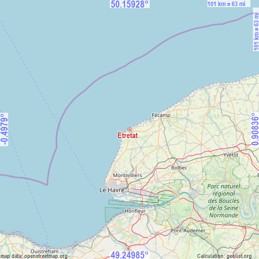
Étretat GPS coordinates[2]
49° 42' 24.084" North, 0° 12' 18.828" East
| Map corner | latitude | longitude |
|---|---|---|
| Upper-left | 50.15928°, | -0.4979° |
| Center: | 49.70669°, | 0.20523° |
| Lower-right: | 49.24985°, | 0.90836° |
| Map W x H: | 101.1×101.1 km | = 62.8×62.8mi |
| max Lat: | 51.07786° ⇑8.4% North |
| Étretat: | 49.70669° |
| min Lat: | ⇓91.6% South 41.3874° |
| min Long | Étretat | max Long |
| -5.08615° | 0.20523° | 9.52242° |
| W 23.8%⇐ | ⇒76.2% E |
Elevation
Elevation of Étretat is 8 m = 26 ft, and this is 185.7 m = 609 ft below average elevation for this country.
| Max E: |
2333 m = 7654 ft | 98.2% |
| Avg. | 193.7 m = 635 ft | |
| Étretat | 8 m = 26 ft | |
Min E: |
-1 m = -3 ft | 1.8% |
See also: France elevation on elevation.city.
Geographical zone
Étretat is located in North temperate zone (between Tropic of Cancer and the Arctic Circle). Distance of this North polar circle is 1874.3 km =1164.6 mi to North.| Distance of | km | miles | from Étretat |
|---|---|---|---|
| North Pole | 4480.2 | 2783.9 | to North |
| Arctic Circle | 1874.3 | 1164.6 | to North |
| Tropic Cancer | 2920.9 | 1815 | to South |
| Equator | 5526.9 | 3434.3 | to South |


Nearby cities:
15 places around Étretat: (largest is in red/bold)
• Bordeaux-Saint-Clair
3.5 km =2.2 mi,  100°
100°
• Criquetot-l’Esneval
8.1 km =5 mi,  147°
147°
• Froberville
9.4 km =5.8 mi,  79°
79°
• Gonneville-la-Mallet
7.6 km =4.7 mi,  170°
170°
• Heuqueville
10.9 km =6.8 mi,  203°
203°
• Le Tilleul
3 km =1.9 mi, 171°
• Les Loges
5.7 km =3.5 mi, 99°
• Mannevillette
12.3 km =7.6 mi,  189°
189°
• Saint-Jouin-Bruneval
7.7 km =4.8 mi, 202°
• Saint-Léonard
11.8 km =7.3 mi,  70°
70°
• Saint-Martin-du-Bec
11.7 km =7.3 mi,  177°
177°
• Turretot
11 km =6.8 mi, 169°
• Yport
8.6 km =5.3 mi, 66°
• Écrainville
10.7 km =6.6 mi,  126°
126°
• Épreville
11.5 km =7.1 mi,  90°
90°
Sources, notices
• [Note1] Compared only with cities in France existing in our database
• [Src1] Map data: © OpenStreetMap contributors (CC-BY-SA)
• [Src2] Other city data from geonames.org with taken over terms of usage.
• [Src3] Geographical zone / Annual Mean Temperature by Robert A. Rohde @ Wikipedia
