Yport geodata
Yport (Normandy) is a populated place; located in France in Europe/Paris (GMT+2) time zone. With population of 1,041 people, there are 8531 cities with bigger population in this country. Compared to other cities in France, 91.8% of cities are located further ↓South; 75.2% of cities are located further →East and 93.6% of cities have higher elevation than Yport. Note1
Administrative division(s):
- Level 1: Normandy
- Level 2: Seine-Maritime
- Level 3: Arrondissement du Havre
- Level 4: Yport


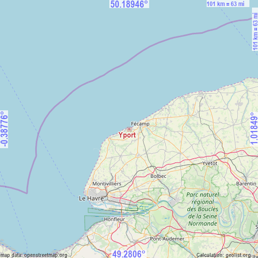
Yport GPS coordinates[2]
49° 44' 13.776" North, 0° 18' 55.332" East
| Map corner | latitude | longitude |
|---|---|---|
| Upper-left | 50.18946°, | -0.38776° |
| Center: | 49.73716°, | 0.31537° |
| Lower-right: | 49.2806°, | 1.01849° |
| Map W x H: | 101.1×101.1 km | = 62.8×62.8mi |
| max Lat: | 51.07786° ⇑8.2% North |
| Yport: | 49.73716° |
| min Lat: | ⇓91.8% South 41.3874° |
| min Long | Yport | max Long |
| -5.08615° | 0.31537° | 9.52242° |
| W 24.8%⇐ | ⇒75.2% E |
Elevation
Elevation of Yport is 21 m = 69 ft, and this is 172.7 m = 567 ft below average elevation for this country.
| Max E: |
2333 m = 7654 ft | 93.6% |
| Avg. | 193.7 m = 635 ft | |
| Yport | 21 m = 69 ft | |
Min E: |
-1 m = -3 ft | 6.4% |
See also: France elevation on elevation.city.
Geographical zone
Yport is located in North temperate zone (between Tropic of Cancer and the Arctic Circle). Distance of this North polar circle is 1870.9 km =1162.5 mi to North.| Distance of | km | miles | from Yport |
|---|---|---|---|
| North Pole | 4476.8 | 2781.8 | to North |
| Arctic Circle | 1870.9 | 1162.5 | to North |
| Tropic Cancer | 2924.3 | 1817.1 | to South |
| Equator | 5530.3 | 3436.4 | to South |


Nearby cities:
15 places around Yport: (largest is in red/bold)
• Bec-de-Mortagne
10.4 km =6.5 mi,  112°
112°
• Bordeaux-Saint-Clair
6 km =3.7 mi,  227°
227°
• Bretteville-du-Grand-Caux
9.9 km =6.2 mi,  142°
142°
• Colleville
10.4 km =6.5 mi,  82°
82°
• Froberville
2.1 km =1.3 mi, 141°
• Fécamp
4.8 km =3 mi,  61°
61°
• Le Tilleul
9.8 km =6.1 mi, 229°
• Les Loges
4.8 km =3 mi,  207°
207°
• Saint-Léonard
3.2 km =2 mi, 79°
• Senneville-sur-Fécamp
8.2 km =5.1 mi, 61°
• Tourville-les-Ifs
6.6 km =4.1 mi, 113°
• Toussaint
7.8 km =4.8 mi,  89°
89°
• Écrainville
9.8 km =6.1 mi,  175°
175°
• Épreville
5 km =3.1 mi,  133°
133°
• Étretat
8.6 km =5.3 mi,  246°
246°
Sources, notices
• [Note1] Compared only with cities in France existing in our database
• [Src1] Map data: © OpenStreetMap contributors (CC-BY-SA)
• [Src2] Other city data from geonames.org with taken over terms of usage.
• [Src3] Geographical zone / Annual Mean Temperature by Robert A. Rohde @ Wikipedia
