Turretot geodata
Turretot (Normandy) is a populated place; located in France in Europe/Paris (GMT+2) time zone. With population of 1,353 people, there are 6797 cities with bigger population in this country. Compared to other cities in France, 90.7% of cities are located further ↓South; 75.9% of cities are located further →East and 61.5% of cities have higher elevation than Turretot. Note1
Administrative division(s):
- Level 1: Normandy
- Level 2: Seine-Maritime
- Level 3: Arrondissement du Havre
- Level 4: Turretot


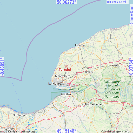
Turretot GPS coordinates[2]
49° 36' 33.228" North, 0° 14' 3.192" East
| Map corner | latitude | longitude |
|---|---|---|
| Upper-left | 50.06273°, | -0.46891° |
| Center: | 49.60923°, | 0.23422° |
| Lower-right: | 49.15148°, | 0.93734° |
| Map W x H: | 101.3×101.3 km | = 62.9×62.9mi |
| max Lat: | 51.07786° ⇑9.3% North |
| Turretot: | 49.60923° |
| min Lat: | ⇓90.7% South 41.3874° |
| min Long | Turretot | max Long |
| -5.08615° | 0.23422° | 9.52242° |
| W 24.1%⇐ | ⇒75.9% E |
Elevation
Elevation of Turretot is 98 m = 322 ft, and this is 95.7 m = 314 ft below average elevation for this country.
| Max E: |
2333 m = 7654 ft | 61.5% |
| Avg. | 193.7 m = 635 ft | |
| Turretot | 98 m = 322 ft | |
Min E: |
-1 m = -3 ft | 38.5% |
See also: France elevation on elevation.city.
Geographical zone
Turretot is located in North temperate zone (between Tropic of Cancer and the Arctic Circle). Distance of this North polar circle is 1885.1 km =1171.3 mi to North.| Distance of | km | miles | from Turretot |
|---|---|---|---|
| North Pole | 4491 | 2790.6 | to North |
| Arctic Circle | 1885.1 | 1171.3 | to North |
| Tropic Cancer | 2910.1 | 1808.3 | to South |
| Equator | 5516 | 3427.5 | to South |


Nearby cities:
15 places around Turretot: (largest is in red/bold)
• Angerville-l’Orcher
4.1 km =2.5 mi,  124°
124°
• Cauville-sur-Mer
7.3 km =4.5 mi,  261°
261°
• Criquetot-l’Esneval
4.6 km =2.9 mi,  29°
29°
• Fontenay
6.6 km =4.1 mi,  213°
213°
• Gonneville-la-Mallet
3.5 km =2.2 mi,  345°
345°
• Heuqueville
6.4 km =4 mi,  276°
276°
• Mannevillette
4.4 km =2.7 mi,  252°
252°
• Manéglise
5.1 km =3.2 mi,  162°
162°
• Rolleville
3.4 km =2.1 mi, 208°
• Sainneville
7.1 km =4.4 mi,  146°
146°
• Saint-Jouin-Bruneval
6.3 km =3.9 mi,  306°
306°
• Saint-Martin-du-Bec
1.8 km =1.1 mi,  243°
243°
• Écrainville
7.9 km =4.9 mi,  55°
55°
• Épouville
5.1 km =3.2 mi,  188°
188°
• Étainhus
7.4 km =4.6 mi,  129°
129°
Sources, notices
• [Note1] Compared only with cities in France existing in our database
• [Src1] Map data: © OpenStreetMap contributors (CC-BY-SA)
• [Src2] Other city data from geonames.org with taken over terms of usage.
• [Src3] Geographical zone / Annual Mean Temperature by Robert A. Rohde @ Wikipedia
