Estillac geodata
Estillac (Nouvelle-Aquitaine) is a populated place; located in France in Europe/Paris (GMT+2) time zone. With population of 1,374 people, there are 6706 cities with bigger population in this country. Compared to other cities in France, 85.9% of cities are located further ↑North; 72.8% of cities are located further →East and 57.4% of cities have lower elevation than Estillac. Note1
Administrative division(s):
- Level 1: Nouvelle-Aquitaine
- Level 2: Département du Lot-et-Garonne
- Level 3: Agen
- Level 4: Estillac


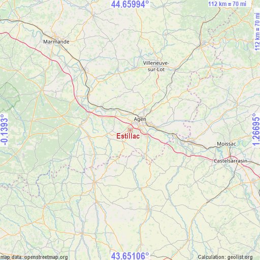
Estillac GPS coordinates[2]
44° 9' 27.576" North, 0° 33' 49.788" East
| Map corner | latitude | longitude |
|---|---|---|
| Upper-left | 44.65994°, | -0.1393° |
| Center: | 44.15766°, | 0.56383° |
| Lower-right: | 43.65106°, | 1.26695° |
| Map W x H: | 112.2×112.2 km | = 69.7×69.7mi |
| max Lat: | 51.07786° ⇑85.9% North |
| Estillac: | 44.15766° |
| min Lat: | ⇓14.1% South 41.3874° |
| min Long | Estillac | max Long |
| -5.08615° | 0.56383° | 9.52242° |
| W 27.2%⇐ | ⇒72.8% E |
Elevation
Elevation of Estillac is 159 m = 522 ft, and this is 34.7 m = 114 ft below average elevation for this country.
| Max E: |
2333 m = 7654 ft | 42.6% |
| Avg. | 193.7 m = 635 ft | |
| Estillac | 159 m = 522 ft | |
Min E: |
-1 m = -3 ft | 57.4% |
See also: France elevation on elevation.city.
Geographical zone
Estillac is located in North temperate zone (between Tropic of Cancer and the Arctic Circle). Distance of this Northern Tropic circle is 2304 km =1431.6 mi to South.| Distance of | km | miles | from Estillac |
|---|---|---|---|
| North Pole | 5097.2 | 3167.3 | to North |
| Arctic Circle | 2491.3 | 1548 | to North |
| Tropic Cancer | 2304 | 1431.6 | to South |
| Equator | 4909.9 | 3050.9 | to South |


Nearby cities:
15 places around Estillac: (largest is in red/bold)
• Agen
6.9 km =4.3 mi,  46°
46°
• Aubiac
1.8 km =1.1 mi,  187°
187°
• Bon-Encontre
8.8 km =5.5 mi,  69°
69°
• Boé
5.2 km =3.2 mi,  87°
87°
• Brax
5.1 km =3.2 mi,  349°
349°
• Castelculier
10.4 km =6.5 mi,  79°
79°
• Colayrac-Saint-Cirq
7.1 km =4.4 mi, 351°
• Laplume
5.7 km =3.5 mi,  208°
208°
• Layrac
8.2 km =5.1 mi,  108°
108°
• Le Passage
5.8 km =3.6 mi,  32°
32°
• Montagnac-sur-Auvignon
8.3 km =5.2 mi,  272°
272°
• Montesquieu
11.1 km =6.9 mi,  296°
296°
• Roquefort
2 km =1.2 mi, 353°
• Sainte-Colombe-en-Bruilhois
4.5 km =2.8 mi, 300°
• Sérignac-sur-Garonne
8.9 km =5.5 mi,  314°
314°
Sources, notices
• [Note1] Compared only with cities in France existing in our database
• [Src1] Map data: © OpenStreetMap contributors (CC-BY-SA)
• [Src2] Other city data from geonames.org with taken over terms of usage.
• [Src3] Geographical zone / Annual Mean Temperature by Robert A. Rohde @ Wikipedia
