Bon-Encontre geodata
Bon-Encontre (Nouvelle-Aquitaine) is a populated place; located in France in Europe/Paris (GMT+2) time zone. With population of 6,076 people, there are 1624 cities with bigger population in this country. Compared to other cities in France, 85.6% of cities are located further ↑North; 71.7% of cities are located further →East and 78.6% of cities have higher elevation than Bon-Encontre. Note1
Administrative division(s):
- Level 1: Nouvelle-Aquitaine
- Level 2: Département du Lot-et-Garonne
- Level 3: Agen
- Level 4: Bon-Encontre


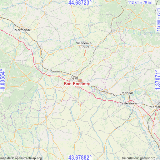
Bon-Encontre GPS coordinates[2]
44° 11' 6.648" North, 0° 40' 3.324" East
| Map corner | latitude | longitude |
|---|---|---|
| Upper-left | 44.68723°, | -0.03554° |
| Center: | 44.18518°, | 0.66759° |
| Lower-right: | 43.67882°, | 1.37071° |
| Map W x H: | 112.1×112.1 km | = 69.7×69.7mi |
| max Lat: | 51.07786° ⇑85.6% North |
| Bon-Encontre: | 44.18518° |
| min Lat: | ⇓14.4% South 41.3874° |
| min Long | Bon-Encontre | max Long |
| -5.08615° | 0.66759° | 9.52242° |
| W 28.3%⇐ | ⇒71.7% E |
Elevation
Elevation of Bon-Encontre is 58 m = 190 ft, and this is 135.7 m = 445 ft below average elevation for this country.
| Max E: |
2333 m = 7654 ft | 78.6% |
| Avg. | 193.7 m = 635 ft | |
| Bon-Encontre | 58 m = 190 ft | |
Min E: |
-1 m = -3 ft | 21.4% |
See also: France elevation on elevation.city.
Geographical zone
Bon-Encontre is located in North temperate zone (between Tropic of Cancer and the Arctic Circle). Distance of this Northern Tropic circle is 2307 km =1433.5 mi to South.| Distance of | km | miles | from Bon-Encontre |
|---|---|---|---|
| North Pole | 5094.1 | 3165.3 | to North |
| Arctic Circle | 2488.2 | 1546.1 | to North |
| Tropic Cancer | 2307 | 1433.5 | to South |
| Equator | 4912.9 | 3052.7 | to South |


Nearby cities:
15 places around Bon-Encontre: (largest is in red/bold)
• Agen
3.7 km =2.3 mi,  296°
296°
• Aubiac
9.8 km =6.1 mi,  240°
240°
• Boé
4.2 km =2.6 mi,  227°
227°
• Brax
9.4 km =5.8 mi,  281°
281°
• Castelculier
2.2 km =1.4 mi,  121°
121°
• Caudecoste
9.5 km =5.9 mi,  143°
143°
• Colayrac-Saint-Cirq
10.1 km =6.3 mi,  293°
293°
• Estillac
8.8 km =5.5 mi,  249°
249°
• Foulayronnes
6.4 km =4 mi,  343°
343°
• Lafox
3.8 km =2.4 mi,  126°
126°
• Layrac
5.7 km =3.5 mi,  184°
184°
• Le Passage
5.5 km =3.4 mi, 289°
• Pont-du-Casse
4.9 km =3 mi,  10°
10°
• Roquefort
8.6 km =5.3 mi,  262°
262°
• Saint-Pierre-de-Clairac
7.5 km =4.7 mi,  94°
94°
Sources, notices
• [Note1] Compared only with cities in France existing in our database
• [Src1] Map data: © OpenStreetMap contributors (CC-BY-SA)
• [Src2] Other city data from geonames.org with taken over terms of usage.
• [Src3] Geographical zone / Annual Mean Temperature by Robert A. Rohde @ Wikipedia
